You are here: Home > Network List > TA - USArray Transportable Network (new EarthScope stations) Stations List
> Station S39A Bolivar, MO, USA > Earthquake Result Viewer
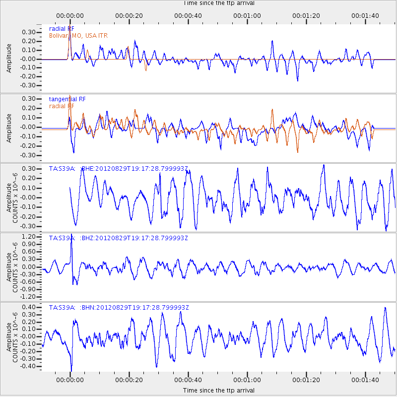
S39A Bolivar, MO, USA - Earthquake Result Viewer
*The percent match for this event was below the threshold and hence no stack was calculated.
| Earthquake location: |
Near East Coast Of Honshu, Japan |
| Earthquake latitude/longitude: |
38.4/141.8 |
| Earthquake time(UTC): |
2012/08/29 (242) 19:05:11 GMT |
| Earthquake Depth: |
47 km |
| Earthquake Magnitude: |
5.8 MB, 5.1 MS, 5.5 MW, 5.5 MW |
| Earthquake Catalog/Contributor: |
WHDF/NEIC |
|
| Network: |
TA USArray Transportable Network (new EarthScope stations) |
| Station: |
S39A Bolivar, MO, USA |
| Lat/Lon: |
37.69 N/93.32 W |
| Elevation: |
331 m |
|
| Distance: |
88.8 deg |
| Az: |
40.621 deg |
| Baz: |
319.863 deg |
| Ray Param: |
$rayparam |
*The percent match for this event was below the threshold and hence was not used in the summary stack. |
|
| Radial Match: |
62.550087 % |
| Radial Bump: |
400 |
| Transverse Match: |
53.855686 % |
| Transverse Bump: |
400 |
| SOD ConfigId: |
469095 |
| Insert Time: |
2013-02-22 09:20:47.478 +0000 |
| GWidth: |
2.5 |
| Max Bumps: |
400 |
| Tol: |
0.001 |
|
Signal To Noise
| Channel | StoN | STA | LTA |
| TA:S39A: :BHZ:20120829T19:17:28.799993Z | 2.6552348 | 4.5744954E-7 | 1.7228216E-7 |
| TA:S39A: :BHN:20120829T19:17:28.799993Z | 1.6166475 | 1.9701169E-7 | 1.2186435E-7 |
| TA:S39A: :BHE:20120829T19:17:28.799993Z | 1.1739402 | 1.473313E-7 | 1.2550154E-7 |
| Arrivals |
| Ps | |
| PpPs | |
| PsPs/PpSs | |


