You are here: Home > Network List > TA - USArray Transportable Network (new EarthScope stations) Stations List
> Station T38A Diamond, MO, USA > Earthquake Result Viewer
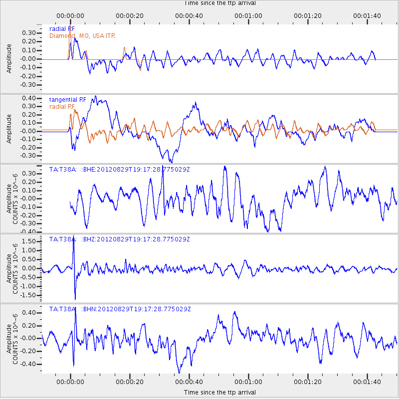
T38A Diamond, MO, USA - Earthquake Result Viewer
*The percent match for this event was below the threshold and hence no stack was calculated.
| Earthquake location: |
Near East Coast Of Honshu, Japan |
| Earthquake latitude/longitude: |
38.4/141.8 |
| Earthquake time(UTC): |
2012/08/29 (242) 19:05:11 GMT |
| Earthquake Depth: |
47 km |
| Earthquake Magnitude: |
5.8 MB, 5.1 MS, 5.5 MW, 5.5 MW |
| Earthquake Catalog/Contributor: |
WHDF/NEIC |
|
| Network: |
TA USArray Transportable Network (new EarthScope stations) |
| Station: |
T38A Diamond, MO, USA |
| Lat/Lon: |
37.04 N/94.29 W |
| Elevation: |
349 m |
|
| Distance: |
88.8 deg |
| Az: |
41.634 deg |
| Baz: |
319.298 deg |
| Ray Param: |
$rayparam |
*The percent match for this event was below the threshold and hence was not used in the summary stack. |
|
| Radial Match: |
47.47639 % |
| Radial Bump: |
400 |
| Transverse Match: |
33.132504 % |
| Transverse Bump: |
400 |
| SOD ConfigId: |
469095 |
| Insert Time: |
2013-02-22 09:21:06.425 +0000 |
| GWidth: |
2.5 |
| Max Bumps: |
400 |
| Tol: |
0.001 |
|
Signal To Noise
| Channel | StoN | STA | LTA |
| TA:T38A: :BHZ:20120829T19:17:28.775029Z | 3.7754896 | 6.3340264E-7 | 1.6776703E-7 |
| TA:T38A: :BHN:20120829T19:17:28.775029Z | 1.751743 | 1.6664008E-7 | 9.512816E-8 |
| TA:T38A: :BHE:20120829T19:17:28.775029Z | 1.1318938 | 1.381063E-7 | 1.2201349E-7 |
| Arrivals |
| Ps | |
| PpPs | |
| PsPs/PpSs | |


