You are here: Home > Network List > TA - USArray Transportable Network (new EarthScope stations) Stations List
> Station V42A Cord, AR, USA > Earthquake Result Viewer
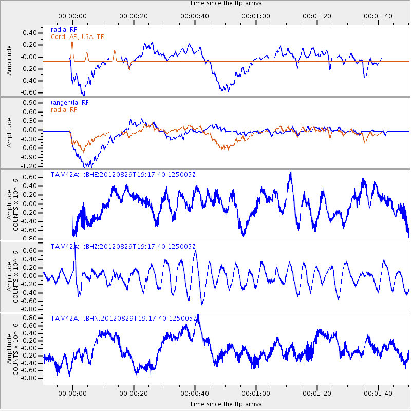
V42A Cord, AR, USA - Earthquake Result Viewer
*The percent match for this event was below the threshold and hence no stack was calculated.
| Earthquake location: |
Near East Coast Of Honshu, Japan |
| Earthquake latitude/longitude: |
38.4/141.8 |
| Earthquake time(UTC): |
2012/08/29 (242) 19:05:11 GMT |
| Earthquake Depth: |
47 km |
| Earthquake Magnitude: |
5.8 MB, 5.1 MS, 5.5 MW, 5.5 MW |
| Earthquake Catalog/Contributor: |
WHDF/NEIC |
|
| Network: |
TA USArray Transportable Network (new EarthScope stations) |
| Station: |
V42A Cord, AR, USA |
| Lat/Lon: |
35.81 N/91.39 W |
| Elevation: |
134 m |
|
| Distance: |
91.3 deg |
| Az: |
40.623 deg |
| Baz: |
321.015 deg |
| Ray Param: |
$rayparam |
*The percent match for this event was below the threshold and hence was not used in the summary stack. |
|
| Radial Match: |
30.300085 % |
| Radial Bump: |
400 |
| Transverse Match: |
63.58328 % |
| Transverse Bump: |
400 |
| SOD ConfigId: |
469095 |
| Insert Time: |
2013-02-22 09:22:40.954 +0000 |
| GWidth: |
2.5 |
| Max Bumps: |
400 |
| Tol: |
0.001 |
|
Signal To Noise
| Channel | StoN | STA | LTA |
| TA:V42A: :BHZ:20120829T19:17:40.125005Z | 2.7440603 | 2.7853966E-7 | 1.01506394E-7 |
| TA:V42A: :BHN:20120829T19:17:40.125005Z | 1.1935799 | 4.9129306E-7 | 4.11613E-7 |
| TA:V42A: :BHE:20120829T19:17:40.125005Z | 0.7184778 | 2.1104931E-7 | 2.9374507E-7 |
| Arrivals |
| Ps | |
| PpPs | |
| PsPs/PpSs | |


