You are here: Home > Network List > TA - USArray Transportable Network (new EarthScope stations) Stations List
> Station R43A Red Bud, IL, USA > Earthquake Result Viewer
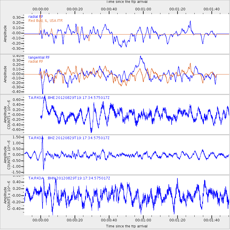
R43A Red Bud, IL, USA - Earthquake Result Viewer
*The percent match for this event was below the threshold and hence no stack was calculated.
| Earthquake location: |
Near East Coast Of Honshu, Japan |
| Earthquake latitude/longitude: |
38.4/141.8 |
| Earthquake time(UTC): |
2012/08/29 (242) 19:05:11 GMT |
| Earthquake Depth: |
47 km |
| Earthquake Magnitude: |
5.8 MB, 5.1 MS, 5.5 MW, 5.5 MW |
| Earthquake Catalog/Contributor: |
WHDF/NEIC |
|
| Network: |
TA USArray Transportable Network (new EarthScope stations) |
| Station: |
R43A Red Bud, IL, USA |
| Lat/Lon: |
38.28 N/89.93 W |
| Elevation: |
186 m |
|
| Distance: |
90.1 deg |
| Az: |
38.173 deg |
| Baz: |
321.918 deg |
| Ray Param: |
$rayparam |
*The percent match for this event was below the threshold and hence was not used in the summary stack. |
|
| Radial Match: |
52.545887 % |
| Radial Bump: |
400 |
| Transverse Match: |
55.64262 % |
| Transverse Bump: |
400 |
| SOD ConfigId: |
469095 |
| Insert Time: |
2013-02-22 09:25:04.819 +0000 |
| GWidth: |
2.5 |
| Max Bumps: |
400 |
| Tol: |
0.001 |
|
Signal To Noise
| Channel | StoN | STA | LTA |
| TA:R43A: :BHZ:20120829T19:17:34.575017Z | 3.7053988 | 5.834058E-7 | 1.574475E-7 |
| TA:R43A: :BHN:20120829T19:17:34.575017Z | 0.8951902 | 1.9463259E-7 | 2.1742039E-7 |
| TA:R43A: :BHE:20120829T19:17:34.575017Z | 1.7277272 | 3.969617E-7 | 2.2975948E-7 |
| Arrivals |
| Ps | |
| PpPs | |
| PsPs/PpSs | |


