You are here: Home > Network List > TA - USArray Transportable Network (new EarthScope stations) Stations List
> Station P47A Martinsville, IN, USA > Earthquake Result Viewer
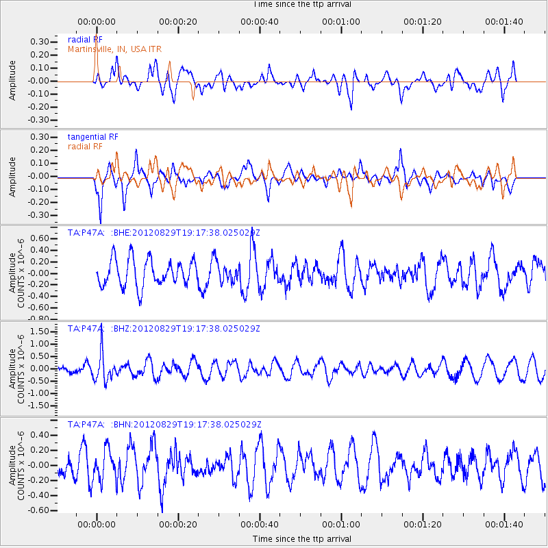
P47A Martinsville, IN, USA - Earthquake Result Viewer
*The percent match for this event was below the threshold and hence no stack was calculated.
| Earthquake location: |
Near East Coast Of Honshu, Japan |
| Earthquake latitude/longitude: |
38.4/141.8 |
| Earthquake time(UTC): |
2012/08/29 (242) 19:05:11 GMT |
| Earthquake Depth: |
47 km |
| Earthquake Magnitude: |
5.8 MB, 5.1 MS, 5.5 MW, 5.5 MW |
| Earthquake Catalog/Contributor: |
WHDF/NEIC |
|
| Network: |
TA USArray Transportable Network (new EarthScope stations) |
| Station: |
P47A Martinsville, IN, USA |
| Lat/Lon: |
39.49 N/86.27 W |
| Elevation: |
246 m |
|
| Distance: |
90.8 deg |
| Az: |
35.163 deg |
| Baz: |
324.231 deg |
| Ray Param: |
$rayparam |
*The percent match for this event was below the threshold and hence was not used in the summary stack. |
|
| Radial Match: |
46.72979 % |
| Radial Bump: |
400 |
| Transverse Match: |
64.72465 % |
| Transverse Bump: |
400 |
| SOD ConfigId: |
469095 |
| Insert Time: |
2013-02-22 09:28:49.231 +0000 |
| GWidth: |
2.5 |
| Max Bumps: |
400 |
| Tol: |
0.001 |
|
Signal To Noise
| Channel | StoN | STA | LTA |
| TA:P47A: :BHZ:20120829T19:17:38.025029Z | 1.7009337 | 5.6380156E-7 | 3.3146594E-7 |
| TA:P47A: :BHN:20120829T19:17:38.025029Z | 0.93882763 | 1.965092E-7 | 2.093134E-7 |
| TA:P47A: :BHE:20120829T19:17:38.025029Z | 0.685385 | 1.57181E-7 | 2.2933244E-7 |
| Arrivals |
| Ps | |
| PpPs | |
| PsPs/PpSs | |


