You are here: Home > Network List > G - GEOSCOPE Stations List
> Station UNM Unam,Mexico > Earthquake Result Viewer
UNM Unam,Mexico - Earthquake Result Viewer

| Earthquake location: |
Near Coast Of Northern Chile |
| Earthquake latitude/longitude: |
-27.5/-70.6 |
| Earthquake time(UTC): |
2002/04/18 (108) 16:08:36 GMT |
| Earthquake Depth: |
62 km |
| Earthquake Magnitude: |
6.2 MB, 6.7 MW, 6.6 MW |
| Earthquake Catalog/Contributor: |
WHDF/NEIC |
|
| Network: |
G GEOSCOPE |
| Station: |
UNM Unam,Mexico |
| Lat/Lon: |
19.33 N/99.18 W |
| Elevation: |
2280 m |
|
| Distance: |
54.2 deg |
| Az: |
326.136 deg |
| Baz: |
148.4 deg |
| Ray Param: |
0.065439515 |
| Estimated Moho Depth: |
17.0 km |
| Estimated Crust Vp/Vs: |
1.71 |
| Assumed Crust Vp: |
6.597 km/s |
| Estimated Crust Vs: |
3.853 km/s |
| Estimated Crust Poisson's Ratio: |
0.24 |
|
| Radial Match: |
96.08107 % |
| Radial Bump: |
400 |
| Transverse Match: |
84.10032 % |
| Transverse Bump: |
400 |
| SOD ConfigId: |
20082 |
| Insert Time: |
2010-02-27 00:39:38.865 +0000 |
| GWidth: |
2.5 |
| Max Bumps: |
400 |
| Tol: |
0.001 |
|
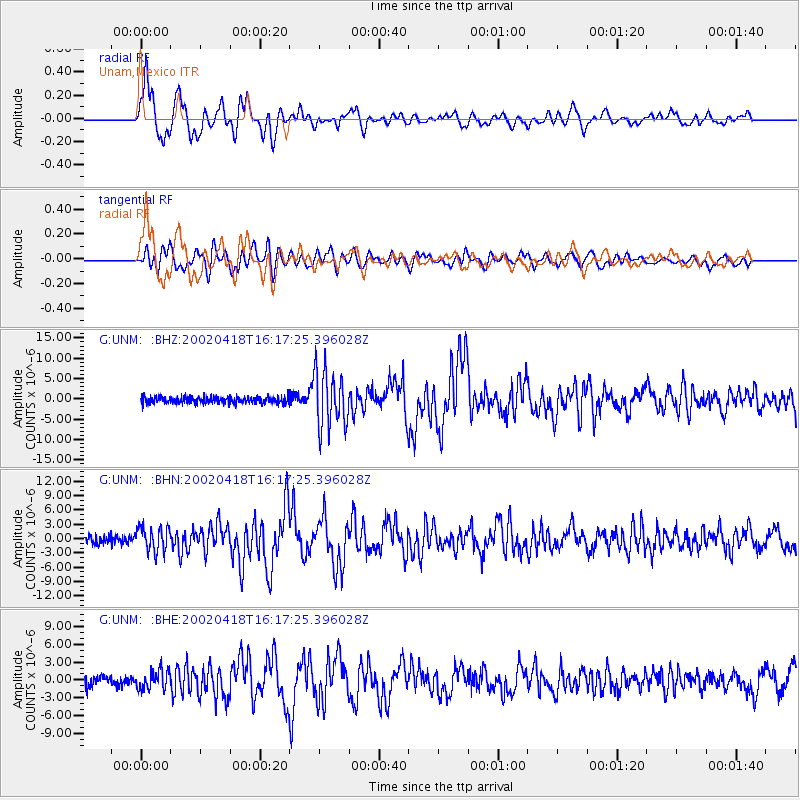
Signal To Noise
| Channel | StoN | STA | LTA |
| G:UNM: :BHN:20020418T16:17:25.396028Z | 3.250358 | 2.5743923E-6 | 7.9203346E-7 |
| G:UNM: :BHE:20020418T16:17:25.396028Z | 2.2813468 | 1.602167E-6 | 7.0229E-7 |
| G:UNM: :BHZ:20020418T16:17:25.396028Z | 8.700751 | 7.0267406E-6 | 8.076016E-7 |
| Arrivals |
| Ps | 1.9 SECOND |
| PpPs | 6.6 SECOND |
| PsPs/PpSs | 8.5 SECOND |


