You are here: Home > Network List > CB - China National Seismic Network Stations List
> Station TIA Taian,Shandong Province > Earthquake Result Viewer
TIA Taian,Shandong Province - Earthquake Result Viewer
| Earthquake location: |
South Of Java, Indonesia |
| Earthquake latitude/longitude: |
-10.7/113.9 |
| Earthquake time(UTC): |
2012/09/03 (247) 18:23:05 GMT |
| Earthquake Depth: |
14 km |
| Earthquake Magnitude: |
6.4 MB, 6.1 MS, 6.1 MW, 6.2 MW |
| Earthquake Catalog/Contributor: |
WHDF/NEIC |
|
| Network: |
CB China National Seismic Network |
| Station: |
TIA Taian,Shandong Province |
| Lat/Lon: |
36.21 N/117.12 E |
| Elevation: |
267 m |
|
| Distance: |
46.8 deg |
| Az: |
3.545 deg |
| Baz: |
184.309 deg |
| Ray Param: |
0.070429504 |
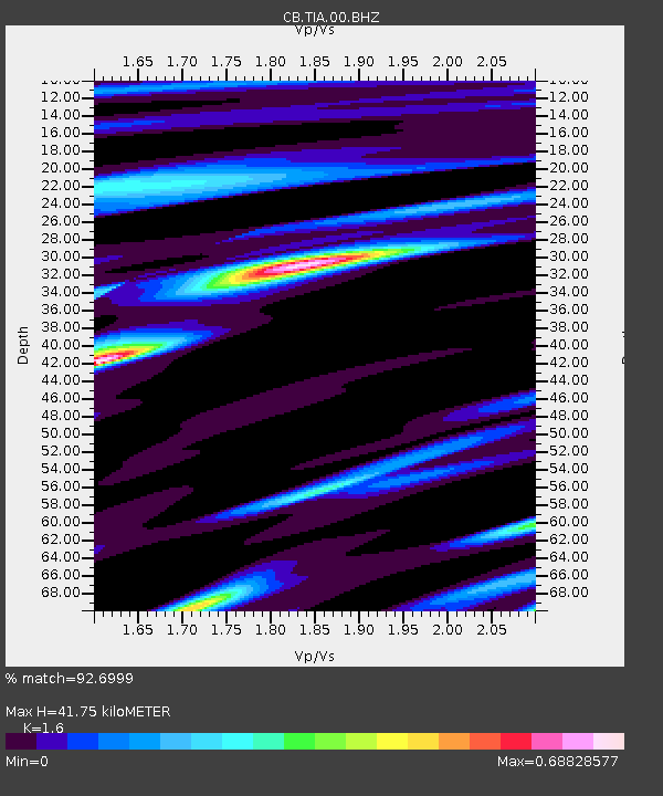
| Estimated Moho Depth: |
41.75 km |
| Estimated Crust Vp/Vs: |
1.60 |
| Assumed Crust Vp: |
6.363 km/s |
| Estimated Crust Vs: |
3.977 km/s |
| Estimated Crust Poisson's Ratio: |
0.18 |
|
| Radial Match: |
92.6999 % |
| Radial Bump: |
338 |
| Transverse Match: |
83.44497 % |
| Transverse Bump: |
400 |
| SOD ConfigId: |
469095 |
| Insert Time: |
2013-02-22 09:50:00.896 +0000 |
| GWidth: |
2.5 |
| Max Bumps: |
400 |
| Tol: |
0.001 |
|

Signal To Noise
| Channel | StoN | STA | LTA |
| CB:TIA:00:BHZ:20120903T18:31:03.039998Z | 6.463538 | 1.2733553E-6 | 1.9700592E-7 |
| CB:TIA:00:BHN:20120903T18:31:03.039998Z | 5.5713573 | 6.875932E-7 | 1.2341573E-7 |
| CB:TIA:00:BHE:20120903T18:31:03.039998Z | 1.5896827 | 1.836931E-7 | 1.15553306E-7 |
| Arrivals |
| Ps | 4.2 SECOND |
| PpPs | 16 SECOND |
| PsPs/PpSs | 20 SECOND |


