You are here: Home > Network List > II - Global Seismograph Network (GSN - IRIS/IDA) Stations List
> Station ARU Arti, Russia > Earthquake Result Viewer
ARU Arti, Russia - Earthquake Result Viewer

| Earthquake location: |
South Of Java, Indonesia |
| Earthquake latitude/longitude: |
-10.7/113.9 |
| Earthquake time(UTC): |
2012/09/03 (247) 18:23:05 GMT |
| Earthquake Depth: |
14 km |
| Earthquake Magnitude: |
6.4 MB, 6.1 MS, 6.1 MW, 6.2 MW |
| Earthquake Catalog/Contributor: |
WHDF/NEIC |
|
| Network: |
II Global Seismograph Network (GSN - IRIS/IDA) |
| Station: |
ARU Arti, Russia |
| Lat/Lon: |
56.43 N/58.56 E |
| Elevation: |
260 m |
|
| Distance: |
81.0 deg |
| Az: |
332.429 deg |
| Baz: |
125.033 deg |
| Ray Param: |
0.047901403 |
| Estimated Moho Depth: |
38.5 km |
| Estimated Crust Vp/Vs: |
1.64 |
| Assumed Crust Vp: |
6.159 km/s |
| Estimated Crust Vs: |
3.755 km/s |
| Estimated Crust Poisson's Ratio: |
0.20 |
|
| Radial Match: |
96.29837 % |
| Radial Bump: |
400 |
| Transverse Match: |
89.8269 % |
| Transverse Bump: |
400 |
| SOD ConfigId: |
469095 |
| Insert Time: |
2013-02-22 09:51:08.960 +0000 |
| GWidth: |
2.5 |
| Max Bumps: |
400 |
| Tol: |
0.001 |
|
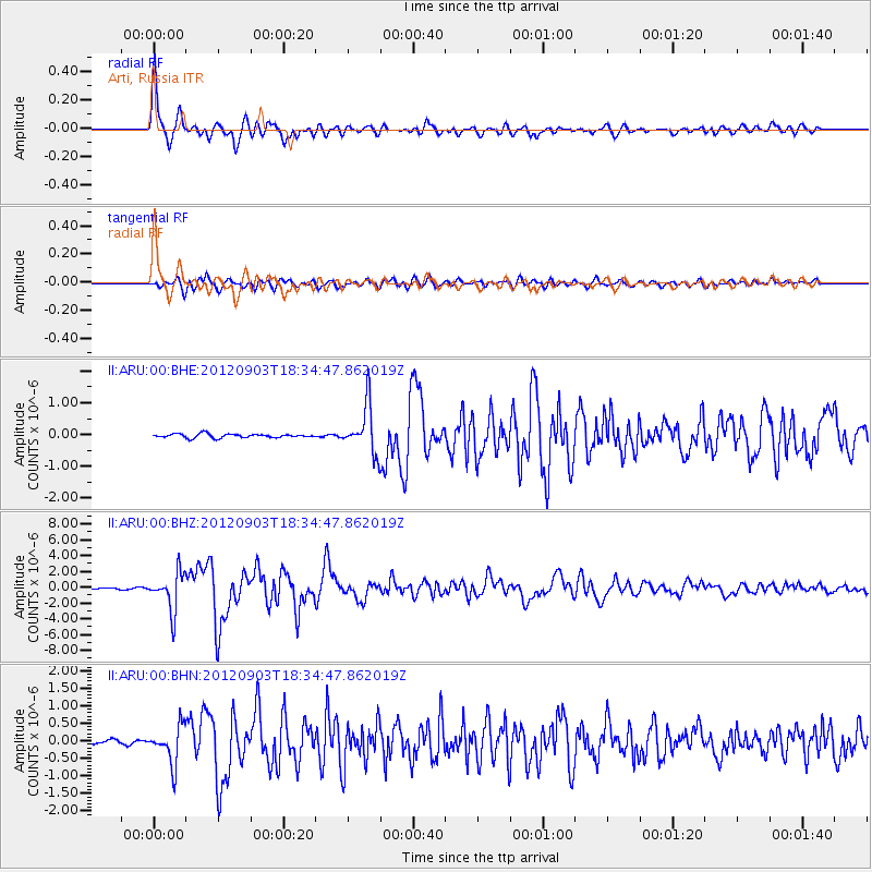
Signal To Noise
| Channel | StoN | STA | LTA |
| II:ARU:00:BHZ:20120903T18:34:47.862019Z | 34.64493 | 2.419794E-6 | 6.984555E-8 |
| II:ARU:00:BHN:20120903T18:34:47.862019Z | 7.240748 | 5.292739E-7 | 7.309658E-8 |
| II:ARU:00:BHE:20120903T18:34:47.862019Z | 12.161792 | 7.470289E-7 | 6.1424245E-8 |
| Arrivals |
| Ps | 4.1 SECOND |
| PpPs | 16 SECOND |
| PsPs/PpSs | 20 SECOND |


