You are here: Home > Network List > G - GEOSCOPE Stations List
> Station UNM Unam,Mexico > Earthquake Result Viewer
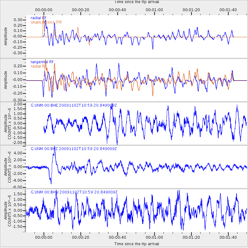
UNM Unam,Mexico - Earthquake Result Viewer
*The percent match for this event was below the threshold and hence no stack was calculated.
| Earthquake location: |
South Of Tonga Islands |
| Earthquake latitude/longitude: |
-24.1/-175.2 |
| Earthquake time(UTC): |
2009/11/02 (306) 10:47:13 GMT |
| Earthquake Depth: |
9.0 km |
| Earthquake Magnitude: |
6.1 MB, 6.1 MS, 6.2 MW, 6.1 MW |
| Earthquake Catalog/Contributor: |
WHDF/NEIC |
|
| Network: |
G GEOSCOPE |
| Station: |
UNM Unam,Mexico |
| Lat/Lon: |
19.33 N/99.18 W |
| Elevation: |
2280 m |
|
| Distance: |
85.7 deg |
| Az: |
66.758 deg |
| Baz: |
242.755 deg |
| Ray Param: |
$rayparam |
*The percent match for this event was below the threshold and hence was not used in the summary stack. |
|
| Radial Match: |
68.93028 % |
| Radial Bump: |
400 |
| Transverse Match: |
70.45534 % |
| Transverse Bump: |
400 |
| SOD ConfigId: |
2622 |
| Insert Time: |
2010-02-27 00:40:24.642 +0000 |
| GWidth: |
2.5 |
| Max Bumps: |
400 |
| Tol: |
0.001 |
|
Signal To Noise
| Channel | StoN | STA | LTA |
| G:UNM:00:BHZ:20091102T10:59:20.849009Z | 5.6732774 | 1.8219844E-6 | 3.2115202E-7 |
| G:UNM:00:BHN:20091102T10:59:20.849009Z | 0.9328578 | 4.784626E-7 | 5.128998E-7 |
| G:UNM:00:BHE:20091102T10:59:20.849009Z | 1.5859619 | 7.5052617E-7 | 4.7323093E-7 |
| Arrivals |
| Ps | |
| PpPs | |
| PsPs/PpSs | |


