You are here: Home > Network List > G - GEOSCOPE Stations List
> Station UNM Unam,Mexico > Earthquake Result Viewer
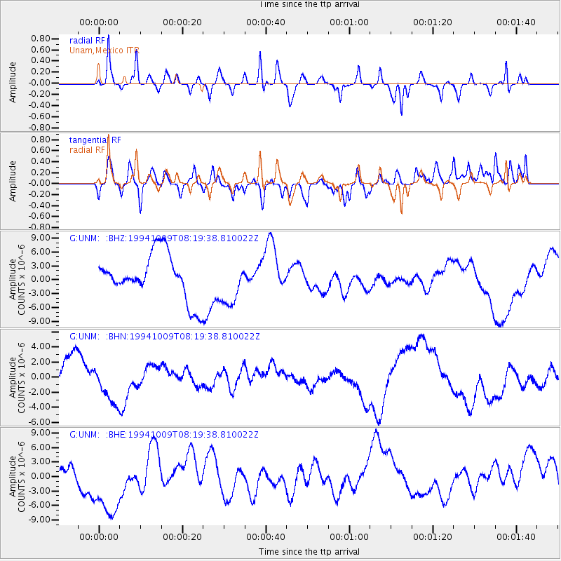
UNM Unam,Mexico - Earthquake Result Viewer
*The percent match for this event was below the threshold and hence no stack was calculated.
| Earthquake location: |
East Of Kuril Islands |
| Earthquake latitude/longitude: |
43.7/148.0 |
| Earthquake time(UTC): |
1994/10/09 (282) 08:07:04 GMT |
| Earthquake Depth: |
42 km |
| Earthquake Magnitude: |
5.9 MB |
| Earthquake Catalog/Contributor: |
WHDF/NEIC |
|
| Network: |
G GEOSCOPE |
| Station: |
UNM Unam,Mexico |
| Lat/Lon: |
19.33 N/99.18 W |
| Elevation: |
2280 m |
|
| Distance: |
92.2 deg |
| Az: |
60.59 deg |
| Baz: |
317.984 deg |
| Ray Param: |
$rayparam |
*The percent match for this event was below the threshold and hence was not used in the summary stack. |
|
| Radial Match: |
49.09585 % |
| Radial Bump: |
288 |
| Transverse Match: |
43.024567 % |
| Transverse Bump: |
400 |
| SOD ConfigId: |
4480 |
| Insert Time: |
2010-02-27 00:40:40.636 +0000 |
| GWidth: |
2.5 |
| Max Bumps: |
400 |
| Tol: |
0.001 |
|
Signal To Noise
| Channel | StoN | STA | LTA |
| G:UNM: :BHN:19941009T08:19:38.810022Z | 1.5522705 | 2.7621595E-6 | 1.7794317E-6 |
| G:UNM: :BHE:19941009T08:19:38.810022Z | 1.9678767 | 7.637172E-6 | 3.88092E-6 |
| G:UNM: :BHZ:19941009T08:19:38.810022Z | 1.0050622 | 4.8737584E-6 | 4.84921E-6 |
| Arrivals |
| Ps | |
| PpPs | |
| PsPs/PpSs | |


