You are here: Home > Network List > TA - USArray Transportable Network (new EarthScope stations) Stations List
> Station G03D McMinnville, OR, USA > Earthquake Result Viewer
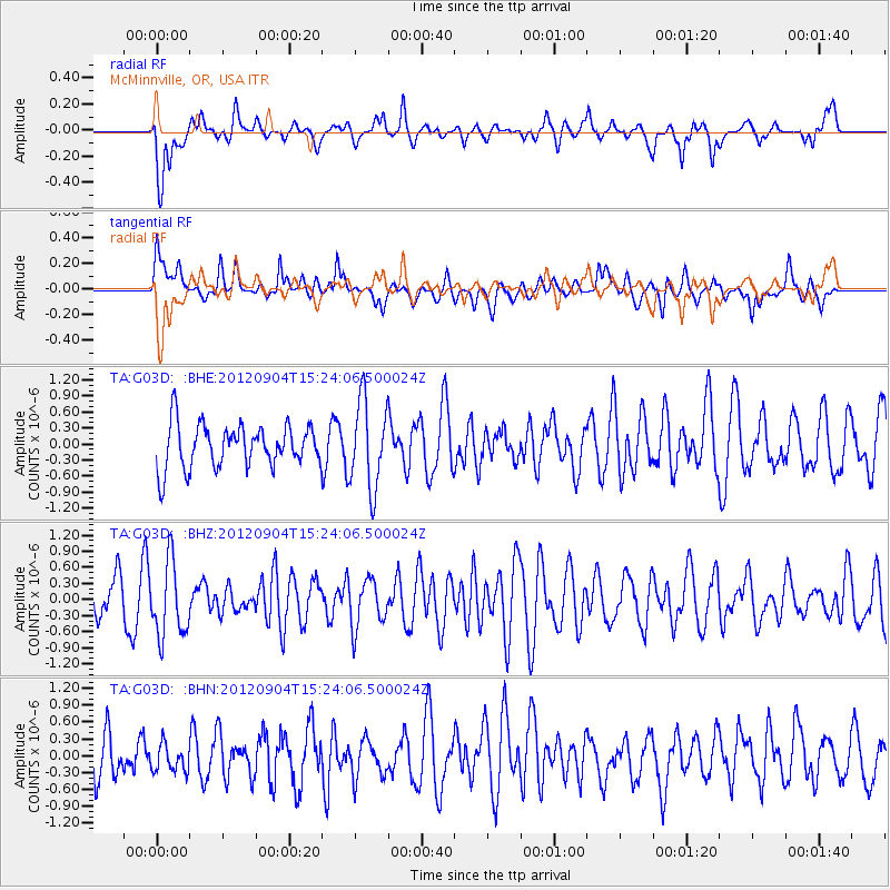
G03D McMinnville, OR, USA - Earthquake Result Viewer
*The percent match for this event was below the threshold and hence no stack was calculated.
| Earthquake location: |
Philippine Islands Region |
| Earthquake latitude/longitude: |
10.6/126.7 |
| Earthquake time(UTC): |
2012/09/04 (248) 15:11:13 GMT |
| Earthquake Depth: |
35 km |
| Earthquake Magnitude: |
5.5 MB, 4.8 MS, 5.2 MW |
| Earthquake Catalog/Contributor: |
WHDF/NEIC |
|
| Network: |
TA USArray Transportable Network (new EarthScope stations) |
| Station: |
G03D McMinnville, OR, USA |
| Lat/Lon: |
45.21 N/123.26 W |
| Elevation: |
222 m |
|
| Distance: |
96.2 deg |
| Az: |
41.92 deg |
| Baz: |
291.692 deg |
| Ray Param: |
$rayparam |
*The percent match for this event was below the threshold and hence was not used in the summary stack. |
|
| Radial Match: |
68.60608 % |
| Radial Bump: |
400 |
| Transverse Match: |
56.935295 % |
| Transverse Bump: |
400 |
| SOD ConfigId: |
469095 |
| Insert Time: |
2013-02-22 10:03:05.766 +0000 |
| GWidth: |
2.5 |
| Max Bumps: |
400 |
| Tol: |
0.001 |
|
Signal To Noise
| Channel | StoN | STA | LTA |
| TA:G03D: :BHZ:20120904T15:24:06.500024Z | 1.812573 | 6.9772716E-7 | 3.8493744E-7 |
| TA:G03D: :BHN:20120904T15:24:06.500024Z | 0.5107141 | 2.3307014E-7 | 4.5636125E-7 |
| TA:G03D: :BHE:20120904T15:24:06.500024Z | 2.0425873 | 8.221642E-7 | 4.0251118E-7 |
| Arrivals |
| Ps | |
| PpPs | |
| PsPs/PpSs | |


