You are here: Home > Network List > CB - China National Seismic Network Stations List
> Station XLT Xilinhaote,Neimeng Province > Earthquake Result Viewer
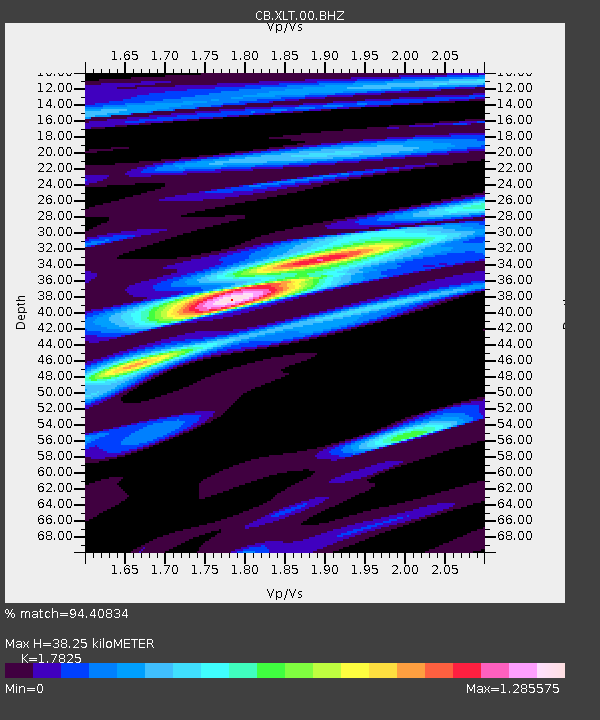
XLT Xilinhaote,Neimeng Province - Earthquake Result Viewer
| Earthquake location: |
Santa Cruz Islands |
| Earthquake latitude/longitude: |
-12.5/166.5 |
| Earthquake time(UTC): |
2012/09/05 (249) 13:09:10 GMT |
| Earthquake Depth: |
27 km |
| Earthquake Magnitude: |
5.6 MB, 5.7 MS, 6.0 MW, 6.0 MW |
| Earthquake Catalog/Contributor: |
WHDF/NEIC |
|
| Network: |
CB China National Seismic Network |
| Station: |
XLT Xilinhaote,Neimeng Province |
| Lat/Lon: |
43.90 N/116.08 E |
| Elevation: |
1030 m |
|
| Distance: |
72.5 deg |
| Az: |
324.237 deg |
| Baz: |
127.848 deg |
| Ray Param: |
0.053611618 |
| Estimated Moho Depth: |
38.25 km |
| Estimated Crust Vp/Vs: |
1.78 |
| Assumed Crust Vp: |
6.459 km/s |
| Estimated Crust Vs: |
3.624 km/s |
| Estimated Crust Poisson's Ratio: |
0.27 |
|
| Radial Match: |
94.40834 % |
| Radial Bump: |
309 |
| Transverse Match: |
81.33407 % |
| Transverse Bump: |
400 |
| SOD ConfigId: |
469095 |
| Insert Time: |
2013-02-22 10:06:18.330 +0000 |
| GWidth: |
2.5 |
| Max Bumps: |
400 |
| Tol: |
0.001 |
|

Signal To Noise
| Channel | StoN | STA | LTA |
| CB:XLT:00:BHZ:20120905T13:20:02.929995Z | 11.423605 | 1.3714117E-6 | 1.200507E-7 |
| CB:XLT:00:BHN:20120905T13:20:02.929995Z | 3.9339104 | 3.5785627E-7 | 9.096706E-8 |
| CB:XLT:00:BHE:20120905T13:20:02.929995Z | 4.930182 | 5.4688417E-7 | 1.1092576E-7 |
| Arrivals |
| Ps | 4.8 SECOND |
| PpPs | 16 SECOND |
| PsPs/PpSs | 21 SECOND |


