You are here: Home > Network List > CI - Caltech Regional Seismic Network Stations List
> Station FUR Furnace Creek, CA, USA > Earthquake Result Viewer
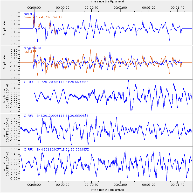
FUR Furnace Creek, CA, USA - Earthquake Result Viewer
*The percent match for this event was below the threshold and hence no stack was calculated.
| Earthquake location: |
Santa Cruz Islands |
| Earthquake latitude/longitude: |
-12.5/166.5 |
| Earthquake time(UTC): |
2012/09/05 (249) 13:09:10 GMT |
| Earthquake Depth: |
27 km |
| Earthquake Magnitude: |
5.6 MB, 5.7 MS, 6.0 MW, 6.0 MW |
| Earthquake Catalog/Contributor: |
WHDF/NEIC |
|
| Network: |
CI Caltech Regional Seismic Network |
| Station: |
FUR Furnace Creek, CA, USA |
| Lat/Lon: |
36.47 N/116.86 W |
| Elevation: |
-37.0 m |
|
| Distance: |
86.8 deg |
| Az: |
51.76 deg |
| Baz: |
252.109 deg |
| Ray Param: |
$rayparam |
*The percent match for this event was below the threshold and hence was not used in the summary stack. |
|
| Radial Match: |
76.21971 % |
| Radial Bump: |
364 |
| Transverse Match: |
54.638756 % |
| Transverse Bump: |
400 |
| SOD ConfigId: |
469095 |
| Insert Time: |
2013-02-22 10:07:18.048 +0000 |
| GWidth: |
2.5 |
| Max Bumps: |
400 |
| Tol: |
0.001 |
|
Signal To Noise
| Channel | StoN | STA | LTA |
| CI:FUR: :BHZ:20120905T13:21:20.669985Z | 2.6103992 | 2.925871E-7 | 1.12085196E-7 |
| CI:FUR: :BHN:20120905T13:21:20.669985Z | 1.8513159 | 2.5358338E-7 | 1.3697468E-7 |
| CI:FUR: :BHE:20120905T13:21:20.669985Z | 0.37863663 | 7.136506E-8 | 1.8847902E-7 |
| Arrivals |
| Ps | |
| PpPs | |
| PsPs/PpSs | |


