You are here: Home > Network List > G - GEOSCOPE Stations List
> Station UNM Unam,Mexico > Earthquake Result Viewer
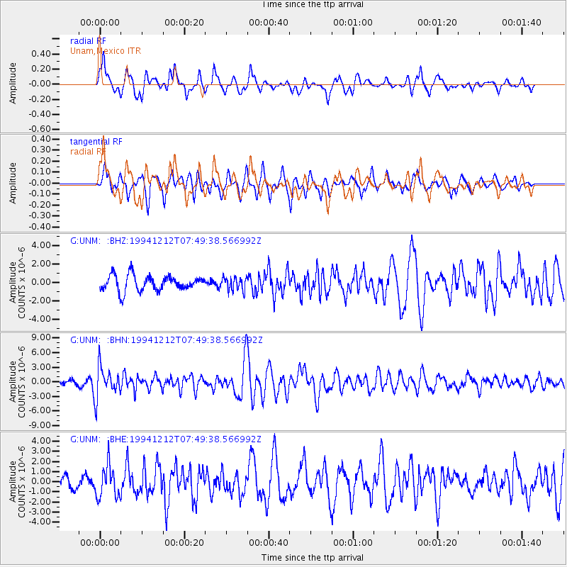
UNM Unam,Mexico - Earthquake Result Viewer
*The percent match for this event was below the threshold and hence no stack was calculated.
| Earthquake location: |
Peru-Bolivia Border Region |
| Earthquake latitude/longitude: |
-17.5/-69.7 |
| Earthquake time(UTC): |
1994/12/12 (346) 07:41:55 GMT |
| Earthquake Depth: |
151 km |
| Earthquake Magnitude: |
5.8 MB, 6.1 UNKNOWN, 6.3 MW |
| Earthquake Catalog/Contributor: |
WHDF/NEIC |
|
| Network: |
G GEOSCOPE |
| Station: |
UNM Unam,Mexico |
| Lat/Lon: |
19.33 N/99.18 W |
| Elevation: |
2280 m |
|
| Distance: |
46.7 deg |
| Az: |
320.25 deg |
| Baz: |
139.747 deg |
| Ray Param: |
$rayparam |
*The percent match for this event was below the threshold and hence was not used in the summary stack. |
|
| Radial Match: |
71.12791 % |
| Radial Bump: |
400 |
| Transverse Match: |
77.566315 % |
| Transverse Bump: |
400 |
| SOD ConfigId: |
4480 |
| Insert Time: |
2010-02-27 00:40:51.129 +0000 |
| GWidth: |
2.5 |
| Max Bumps: |
400 |
| Tol: |
0.001 |
|
Signal To Noise
| Channel | StoN | STA | LTA |
| G:UNM: :BHN:19941212T07:49:38.566992Z | 5.766781 | 3.0712906E-6 | 5.325832E-7 |
| G:UNM: :BHE:19941212T07:49:38.566992Z | 1.5970892 | 1.5821613E-6 | 9.906531E-7 |
| G:UNM: :BHZ:19941212T07:49:38.566992Z | 0.8597875 | 7.2369414E-7 | 8.4171273E-7 |
| Arrivals |
| Ps | |
| PpPs | |
| PsPs/PpSs | |


