You are here: Home > Network List > TA - USArray Transportable Network (new EarthScope stations) Stations List
> Station A04D Lummi Island, WA, USA > Earthquake Result Viewer
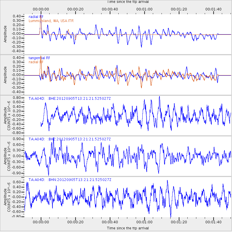
A04D Lummi Island, WA, USA - Earthquake Result Viewer
*The percent match for this event was below the threshold and hence no stack was calculated.
| Earthquake location: |
Santa Cruz Islands |
| Earthquake latitude/longitude: |
-12.5/166.5 |
| Earthquake time(UTC): |
2012/09/05 (249) 13:09:10 GMT |
| Earthquake Depth: |
27 km |
| Earthquake Magnitude: |
5.6 MB, 5.7 MS, 6.0 MW, 6.0 MW |
| Earthquake Catalog/Contributor: |
WHDF/NEIC |
|
| Network: |
TA USArray Transportable Network (new EarthScope stations) |
| Station: |
A04D Lummi Island, WA, USA |
| Lat/Lon: |
48.72 N/122.71 W |
| Elevation: |
13 m |
|
| Distance: |
87.0 deg |
| Az: |
38.769 deg |
| Baz: |
247.445 deg |
| Ray Param: |
$rayparam |
*The percent match for this event was below the threshold and hence was not used in the summary stack. |
|
| Radial Match: |
40.556385 % |
| Radial Bump: |
400 |
| Transverse Match: |
40.948032 % |
| Transverse Bump: |
400 |
| SOD ConfigId: |
469095 |
| Insert Time: |
2013-02-22 10:10:30.292 +0000 |
| GWidth: |
2.5 |
| Max Bumps: |
400 |
| Tol: |
0.001 |
|
Signal To Noise
| Channel | StoN | STA | LTA |
| TA:A04D: :BHZ:20120905T13:21:21.525027Z | 2.512233 | 4.1902132E-7 | 1.6679236E-7 |
| TA:A04D: :BHN:20120905T13:21:21.525027Z | 0.34718192 | 1.3638807E-7 | 3.9284322E-7 |
| TA:A04D: :BHE:20120905T13:21:21.525027Z | 0.7046761 | 1.716574E-7 | 2.4359758E-7 |
| Arrivals |
| Ps | |
| PpPs | |
| PsPs/PpSs | |


