You are here: Home > Network List > G - GEOSCOPE Stations List
> Station UNM Unam,Mexico > Earthquake Result Viewer
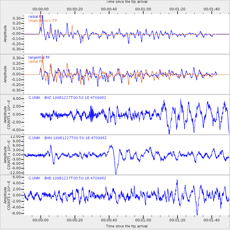
UNM Unam,Mexico - Earthquake Result Viewer
*The percent match for this event was below the threshold and hence no stack was calculated.
| Earthquake location: |
Fiji Islands Region |
| Earthquake latitude/longitude: |
-21.6/-176.4 |
| Earthquake time(UTC): |
1998/12/27 (361) 00:38:26 GMT |
| Earthquake Depth: |
144 km |
| Earthquake Magnitude: |
6.1 MB, 6.9 UNKNOWN, 6.6 ME |
| Earthquake Catalog/Contributor: |
WHDF/NEIC |
|
| Network: |
G GEOSCOPE |
| Station: |
UNM Unam,Mexico |
| Lat/Lon: |
19.33 N/99.18 W |
| Elevation: |
2280 m |
|
| Distance: |
85.8 deg |
| Az: |
67.427 deg |
| Baz: |
245.476 deg |
| Ray Param: |
$rayparam |
*The percent match for this event was below the threshold and hence was not used in the summary stack. |
|
| Radial Match: |
86.67594 % |
| Radial Bump: |
400 |
| Transverse Match: |
72.24022 % |
| Transverse Bump: |
400 |
| SOD ConfigId: |
4480 |
| Insert Time: |
2010-02-27 00:41:02.282 +0000 |
| GWidth: |
2.5 |
| Max Bumps: |
400 |
| Tol: |
0.001 |
|
Signal To Noise
| Channel | StoN | STA | LTA |
| G:UNM: :BHN:19981227T00:50:18.470996Z | 2.4142551 | 1.057849E-6 | 4.3816786E-7 |
| G:UNM: :BHE:19981227T00:50:18.470996Z | 1.2235141 | 7.766385E-7 | 6.347606E-7 |
| G:UNM: :BHZ:19981227T00:50:18.470996Z | 1.6439816 | 8.479966E-7 | 5.158188E-7 |
| Arrivals |
| Ps | |
| PpPs | |
| PsPs/PpSs | |


