You are here: Home > Network List > TA - USArray Transportable Network (new EarthScope stations) Stations List
> Station R55A Marlinton, WV, USA > Earthquake Result Viewer
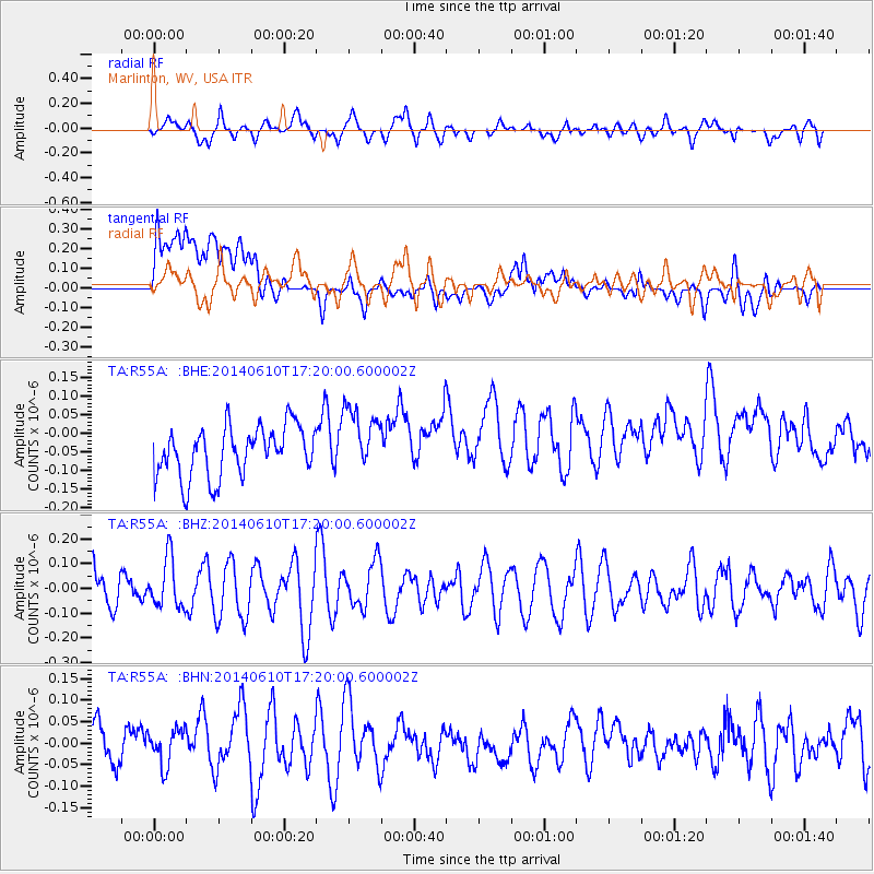
R55A Marlinton, WV, USA - Earthquake Result Viewer
*The percent match for this event was below the threshold and hence no stack was calculated.
| Earthquake location: |
Near Coast Of Peru |
| Earthquake latitude/longitude: |
-15.9/-75.1 |
| Earthquake time(UTC): |
2014/06/10 (161) 17:11:09 GMT |
| Earthquake Depth: |
30 km |
| Earthquake Magnitude: |
4.7 mb |
| Earthquake Catalog/Contributor: |
ISC/ISC |
|
| Network: |
TA USArray Transportable Network (new EarthScope stations) |
| Station: |
R55A Marlinton, WV, USA |
| Lat/Lon: |
38.28 N/80.12 W |
| Elevation: |
833 m |
|
| Distance: |
54.1 deg |
| Az: |
355.083 deg |
| Baz: |
173.983 deg |
| Ray Param: |
$rayparam |
*The percent match for this event was below the threshold and hence was not used in the summary stack. |
|
| Radial Match: |
52.40356 % |
| Radial Bump: |
400 |
| Transverse Match: |
42.072178 % |
| Transverse Bump: |
400 |
| SOD ConfigId: |
3390531 |
| Insert Time: |
2019-04-12 05:47:30.975 +0000 |
| GWidth: |
2.5 |
| Max Bumps: |
400 |
| Tol: |
0.001 |
|
Signal To Noise
| Channel | StoN | STA | LTA |
| TA:R55A: :BHZ:20140610T17:20:00.600002Z | 1.4363519 | 1.0044036E-7 | 6.99274E-8 |
| TA:R55A: :BHN:20140610T17:20:00.600002Z | 0.7576436 | 4.1567073E-8 | 5.4863627E-8 |
| TA:R55A: :BHE:20140610T17:20:00.600002Z | 1.2911342 | 8.7204135E-8 | 6.754072E-8 |
| Arrivals |
| Ps | |
| PpPs | |
| PsPs/PpSs | |


