You are here: Home > Network List > TA - USArray Transportable Network (new EarthScope stations) Stations List
> Station W56A Indian Trail, NC, USA > Earthquake Result Viewer
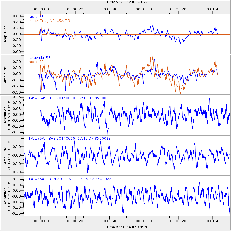
W56A Indian Trail, NC, USA - Earthquake Result Viewer
*The percent match for this event was below the threshold and hence no stack was calculated.
| Earthquake location: |
Near Coast Of Peru |
| Earthquake latitude/longitude: |
-15.9/-75.1 |
| Earthquake time(UTC): |
2014/06/10 (161) 17:11:09 GMT |
| Earthquake Depth: |
30 km |
| Earthquake Magnitude: |
4.7 mb |
| Earthquake Catalog/Contributor: |
ISC/ISC |
|
| Network: |
TA USArray Transportable Network (new EarthScope stations) |
| Station: |
W56A Indian Trail, NC, USA |
| Lat/Lon: |
35.13 N/80.58 W |
| Elevation: |
177 m |
|
| Distance: |
51.0 deg |
| Az: |
354.174 deg |
| Baz: |
173.154 deg |
| Ray Param: |
$rayparam |
*The percent match for this event was below the threshold and hence was not used in the summary stack. |
|
| Radial Match: |
33.543568 % |
| Radial Bump: |
400 |
| Transverse Match: |
38.062035 % |
| Transverse Bump: |
400 |
| SOD ConfigId: |
3390531 |
| Insert Time: |
2019-04-12 05:47:45.092 +0000 |
| GWidth: |
2.5 |
| Max Bumps: |
400 |
| Tol: |
0.001 |
|
Signal To Noise
| Channel | StoN | STA | LTA |
| TA:W56A: :BHZ:20140610T17:19:37.850002Z | 1.2848394 | 8.039627E-8 | 6.257301E-8 |
| TA:W56A: :BHN:20140610T17:19:37.850002Z | 0.7429483 | 3.3699877E-8 | 4.5359656E-8 |
| TA:W56A: :BHE:20140610T17:19:37.850002Z | 1.1341623 | 5.302173E-8 | 4.674968E-8 |
| Arrivals |
| Ps | |
| PpPs | |
| PsPs/PpSs | |


