You are here: Home > Network List > AV - Alaska Volcano Observatory Stations List
> Station SPCR Ckakachatna River, Mount Spurr, Alaska > Earthquake Result Viewer
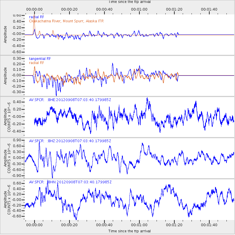
SPCR Ckakachatna River, Mount Spurr, Alaska - Earthquake Result Viewer
*The percent match for this event was below the threshold and hence no stack was calculated.
| Earthquake location: |
Mariana Islands Region |
| Earthquake latitude/longitude: |
21.5/145.9 |
| Earthquake time(UTC): |
2012/09/08 (252) 06:54:18 GMT |
| Earthquake Depth: |
5.0 km |
| Earthquake Magnitude: |
5.6 MB, 5.4 MS, 5.7 MW, 5.6 MW |
| Earthquake Catalog/Contributor: |
WHDF/NEIC |
|
| Network: |
AV Alaska Volcano Observatory |
| Station: |
SPCR Ckakachatna River, Mount Spurr, Alaska |
| Lat/Lon: |
61.20 N/152.21 W |
| Elevation: |
984 m |
|
| Distance: |
57.9 deg |
| Az: |
30.281 deg |
| Baz: |
255.821 deg |
| Ray Param: |
$rayparam |
*The percent match for this event was below the threshold and hence was not used in the summary stack. |
|
| Radial Match: |
46.937004 % |
| Radial Bump: |
400 |
| Transverse Match: |
53.780735 % |
| Transverse Bump: |
359 |
| SOD ConfigId: |
469095 |
| Insert Time: |
2013-02-22 16:16:22.606 +0000 |
| GWidth: |
2.5 |
| Max Bumps: |
400 |
| Tol: |
0.001 |
|
Signal To Noise
| Channel | StoN | STA | LTA |
| AV:SPCR: :BHZ:20120908T07:03:40.179985Z | 2.9863915 | 3.8997533E-7 | 1.3058413E-7 |
| AV:SPCR: :BHN:20120908T07:03:40.179985Z | 1.301235 | 2.1527772E-7 | 1.6544108E-7 |
| AV:SPCR: :BHE:20120908T07:03:40.179985Z | 1.8915216 | 2.4266694E-7 | 1.2829192E-7 |
| Arrivals |
| Ps | |
| PpPs | |
| PsPs/PpSs | |


