You are here: Home > Network List > UU - University of Utah Regional Network Stations List
> Station ASI2 Darling Creek, Challis, ID, USA > Earthquake Result Viewer
ASI2 Darling Creek, Challis, ID, USA - Earthquake Result Viewer
| Earthquake location: |
Near Coast Of Peru |
| Earthquake latitude/longitude: |
-15.9/-75.1 |
| Earthquake time(UTC): |
2014/06/10 (161) 17:11:09 GMT |
| Earthquake Depth: |
30 km |
| Earthquake Magnitude: |
4.7 mb |
| Earthquake Catalog/Contributor: |
ISC/ISC |
|
| Network: |
UU University of Utah Regional Network |
| Station: |
ASI2 Darling Creek, Challis, ID, USA |
| Lat/Lon: |
44.57 N/114.26 W |
| Elevation: |
1600 m |
|
| Distance: |
69.9 deg |
| Az: |
331.258 deg |
| Baz: |
139.642 deg |
| Ray Param: |
0.055275574 |
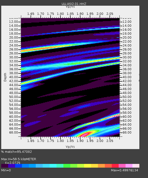
| Estimated Moho Depth: |
59.5 km |
| Estimated Crust Vp/Vs: |
2.07 |
| Assumed Crust Vp: |
6.577 km/s |
| Estimated Crust Vs: |
3.173 km/s |
| Estimated Crust Poisson's Ratio: |
0.35 |
|
| Radial Match: |
95.47082 % |
| Radial Bump: |
134 |
| Transverse Match: |
97.30568 % |
| Transverse Bump: |
71 |
| SOD ConfigId: |
3390531 |
| Insert Time: |
2019-04-12 05:48:19.581 +0000 |
| GWidth: |
2.5 |
| Max Bumps: |
400 |
| Tol: |
0.001 |
|

Signal To Noise
| Channel | StoN | STA | LTA |
| UU:ASI2:01:HHZ:20140610T17:21:46.957974Z | 3.489855 | 2.7246104E-8 | 7.80723E-9 |
| UU:ASI2:01:HHN:20140610T17:21:46.957974Z | 1.6262255 | 1.19273205E-8 | 7.334359E-9 |
| UU:ASI2:01:HHE:20140610T17:21:46.957974Z | 1.7026669 | 3.132978E-8 | 1.8400417E-8 |
| Arrivals |
| Ps | 10 SECOND |
| PpPs | 27 SECOND |
| PsPs/PpSs | 37 SECOND |


