You are here: Home > Network List > G - GEOSCOPE Stations List
> Station UNM Unam,Mexico > Earthquake Result Viewer
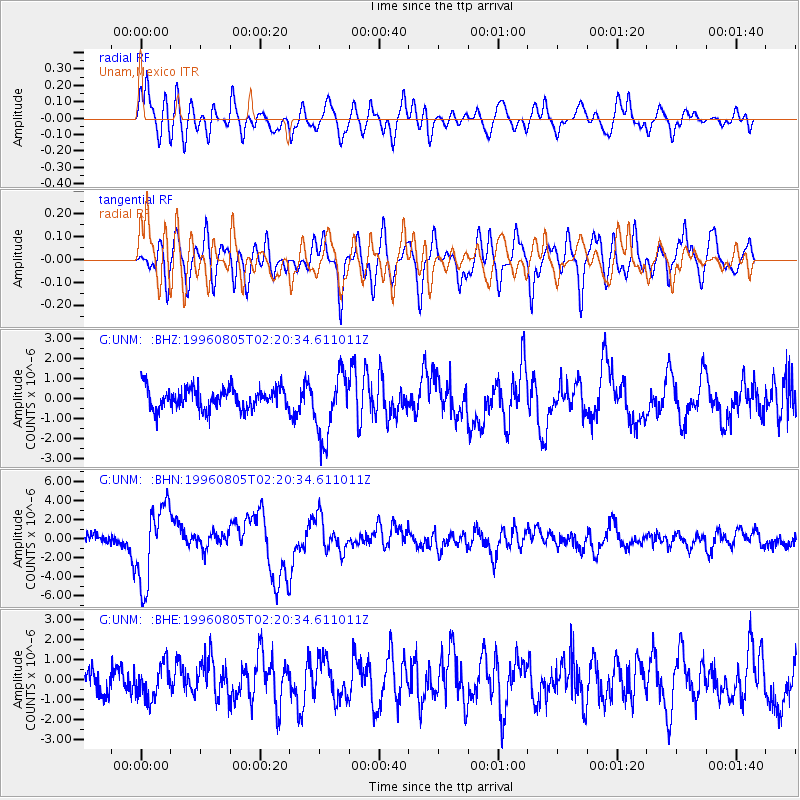
UNM Unam,Mexico - Earthquake Result Viewer
*The percent match for this event was below the threshold and hence no stack was calculated.
| Earthquake location: |
Tonga Islands |
| Earthquake latitude/longitude: |
-15.3/-173.1 |
| Earthquake time(UTC): |
1996/08/05 (218) 02:08:58 GMT |
| Earthquake Depth: |
41 km |
| Earthquake Magnitude: |
6.0 MB, 6.7 MS, 6.7 UNKNOWN, 6.2 ME |
| Earthquake Catalog/Contributor: |
WHDF/NEIC |
|
| Network: |
G GEOSCOPE |
| Station: |
UNM Unam,Mexico |
| Lat/Lon: |
19.33 N/99.18 W |
| Elevation: |
2280 m |
|
| Distance: |
80.4 deg |
| Az: |
66.964 deg |
| Baz: |
250.146 deg |
| Ray Param: |
$rayparam |
*The percent match for this event was below the threshold and hence was not used in the summary stack. |
|
| Radial Match: |
78.45479 % |
| Radial Bump: |
400 |
| Transverse Match: |
65.59103 % |
| Transverse Bump: |
400 |
| SOD ConfigId: |
4480 |
| Insert Time: |
2010-02-27 00:41:38.543 +0000 |
| GWidth: |
2.5 |
| Max Bumps: |
400 |
| Tol: |
0.001 |
|
Signal To Noise
| Channel | StoN | STA | LTA |
| G:UNM: :BHN:19960805T02:20:34.611011Z | 10.110834 | 4.138131E-6 | 4.092769E-7 |
| G:UNM: :BHE:19960805T02:20:34.611011Z | 1.5889149 | 8.58938E-7 | 5.405815E-7 |
| G:UNM: :BHZ:19960805T02:20:34.611011Z | 2.9635706 | 1.6057068E-6 | 5.418149E-7 |
| Arrivals |
| Ps | |
| PpPs | |
| PsPs/PpSs | |


