You are here: Home > Network List > IW - Intermountain West Stations List
> Station MOOW Moose Ponds, Wyoming, USA > Earthquake Result Viewer
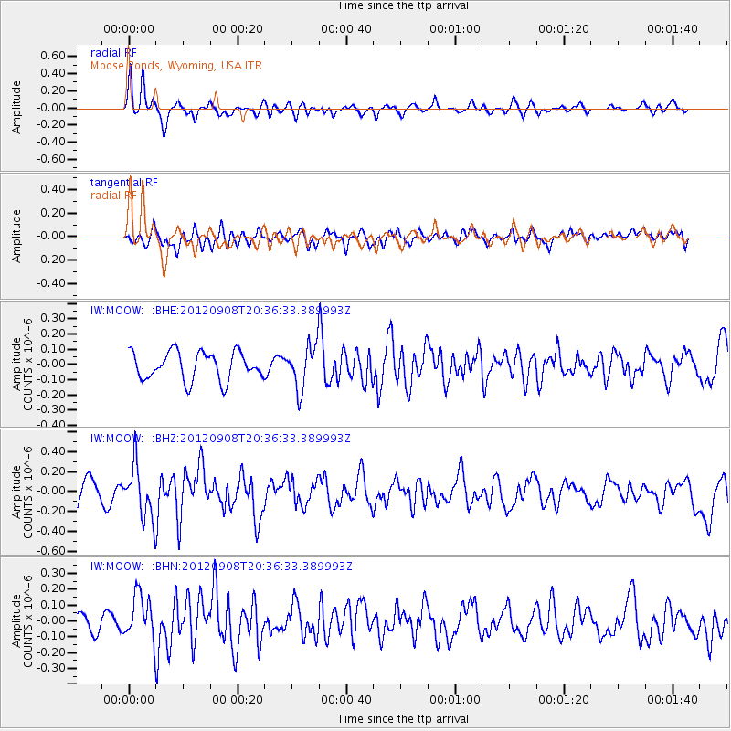
MOOW Moose Ponds, Wyoming, USA - Earthquake Result Viewer
*The percent match for this event was below the threshold and hence no stack was calculated.
| Earthquake location: |
Costa Rica |
| Earthquake latitude/longitude: |
10.1/-85.3 |
| Earthquake time(UTC): |
2012/09/08 (252) 20:29:31 GMT |
| Earthquake Depth: |
35 km |
| Earthquake Magnitude: |
5.7 MB, 5.1 MS, 5.7 MW, 5.7 MW |
| Earthquake Catalog/Contributor: |
WHDF/NEIC |
|
| Network: |
IW Intermountain West |
| Station: |
MOOW Moose Ponds, Wyoming, USA |
| Lat/Lon: |
43.75 N/110.74 W |
| Elevation: |
2128 m |
|
| Distance: |
40.1 deg |
| Az: |
331.151 deg |
| Baz: |
139.03 deg |
| Ray Param: |
$rayparam |
*The percent match for this event was below the threshold and hence was not used in the summary stack. |
|
| Radial Match: |
74.325096 % |
| Radial Bump: |
368 |
| Transverse Match: |
57.60422 % |
| Transverse Bump: |
400 |
| SOD ConfigId: |
476835 |
| Insert Time: |
2013-02-22 17:19:23.855 +0000 |
| GWidth: |
2.5 |
| Max Bumps: |
400 |
| Tol: |
0.001 |
|
Signal To Noise
| Channel | StoN | STA | LTA |
| IW:MOOW: :BHZ:20120908T20:36:33.389993Z | 2.0276315 | 2.6627455E-7 | 1.3132295E-7 |
| IW:MOOW: :BHN:20120908T20:36:33.389993Z | 1.2071408 | 1.3881323E-7 | 1.1499341E-7 |
| IW:MOOW: :BHE:20120908T20:36:33.389993Z | 1.5733124 | 1.4384784E-7 | 9.142993E-8 |
| Arrivals |
| Ps | |
| PpPs | |
| PsPs/PpSs | |


