You are here: Home > Network List > TA - USArray Transportable Network (new EarthScope stations) Stations List
> Station N42A Yates City, IL, USA > Earthquake Result Viewer
N42A Yates City, IL, USA - Earthquake Result Viewer
| Earthquake location: |
Costa Rica |
| Earthquake latitude/longitude: |
10.1/-85.3 |
| Earthquake time(UTC): |
2012/09/08 (252) 20:29:31 GMT |
| Earthquake Depth: |
35 km |
| Earthquake Magnitude: |
5.7 MB, 5.1 MS, 5.7 MW, 5.7 MW |
| Earthquake Catalog/Contributor: |
WHDF/NEIC |
|
| Network: |
TA USArray Transportable Network (new EarthScope stations) |
| Station: |
N42A Yates City, IL, USA |
| Lat/Lon: |
40.83 N/90.03 W |
| Elevation: |
205 m |
|
| Distance: |
30.9 deg |
| Az: |
353.03 deg |
| Baz: |
170.939 deg |
| Ray Param: |
0.079175435 |
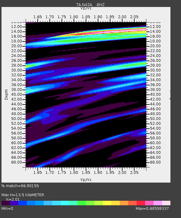
| Estimated Moho Depth: |
13.5 km |
| Estimated Crust Vp/Vs: |
2.01 |
| Assumed Crust Vp: |
6.498 km/s |
| Estimated Crust Vs: |
3.233 km/s |
| Estimated Crust Poisson's Ratio: |
0.34 |
|
| Radial Match: |
86.90155 % |
| Radial Bump: |
400 |
| Transverse Match: |
46.62932 % |
| Transverse Bump: |
400 |
| SOD ConfigId: |
476835 |
| Insert Time: |
2013-02-22 17:29:21.721 +0000 |
| GWidth: |
2.5 |
| Max Bumps: |
400 |
| Tol: |
0.001 |
|
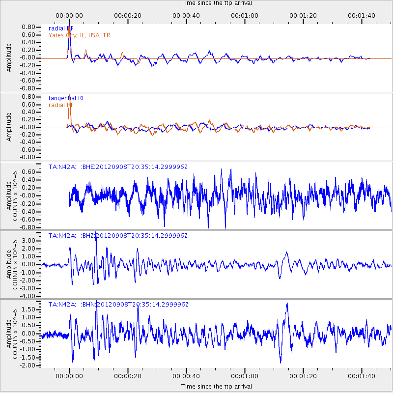
Signal To Noise
| Channel | StoN | STA | LTA |
| TA:N42A: :BHZ:20120908T20:35:14.299996Z | 9.413453 | 1.0513075E-6 | 1.1168139E-7 |
| TA:N42A: :BHN:20120908T20:35:14.299996Z | 3.9927163 | 6.991459E-7 | 1.7510534E-7 |
| TA:N42A: :BHE:20120908T20:35:14.299996Z | 1.5061243 | 2.4634238E-7 | 1.6356046E-7 |
| Arrivals |
| Ps | 2.3 SECOND |
| PpPs | 5.8 SECOND |
| PsPs/PpSs | 8.1 SECOND |


