You are here: Home > Network List > TA - USArray Transportable Network (new EarthScope stations) Stations List
> Station N45A Kentland, IN, USA > Earthquake Result Viewer
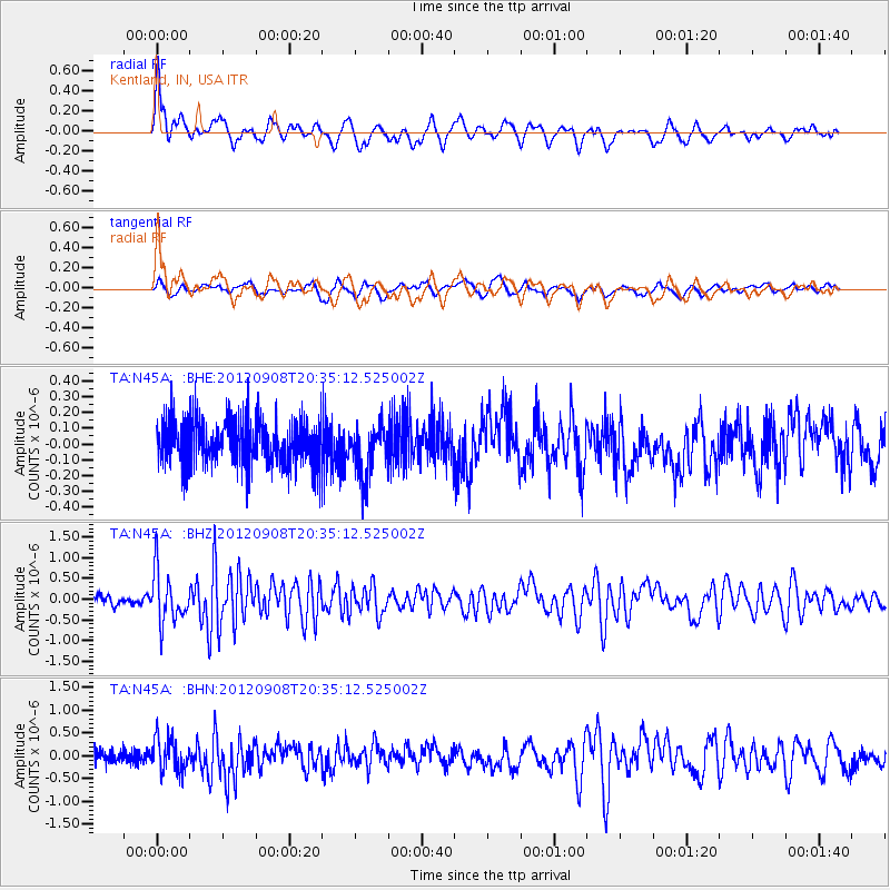
N45A Kentland, IN, USA - Earthquake Result Viewer
*The percent match for this event was below the threshold and hence no stack was calculated.
| Earthquake location: |
Costa Rica |
| Earthquake latitude/longitude: |
10.1/-85.3 |
| Earthquake time(UTC): |
2012/09/08 (252) 20:29:31 GMT |
| Earthquake Depth: |
35 km |
| Earthquake Magnitude: |
5.7 MB, 5.1 MS, 5.7 MW, 5.7 MW |
| Earthquake Catalog/Contributor: |
WHDF/NEIC |
|
| Network: |
TA USArray Transportable Network (new EarthScope stations) |
| Station: |
N45A Kentland, IN, USA |
| Lat/Lon: |
40.85 N/87.51 W |
| Elevation: |
206 m |
|
| Distance: |
30.7 deg |
| Az: |
356.747 deg |
| Baz: |
175.776 deg |
| Ray Param: |
$rayparam |
*The percent match for this event was below the threshold and hence was not used in the summary stack. |
|
| Radial Match: |
75.48177 % |
| Radial Bump: |
400 |
| Transverse Match: |
63.573315 % |
| Transverse Bump: |
400 |
| SOD ConfigId: |
476835 |
| Insert Time: |
2013-02-22 17:31:52.316 +0000 |
| GWidth: |
2.5 |
| Max Bumps: |
400 |
| Tol: |
0.001 |
|
Signal To Noise
| Channel | StoN | STA | LTA |
| TA:N45A: :BHZ:20120908T20:35:12.525002Z | 3.0874908 | 5.989181E-7 | 1.9398216E-7 |
| TA:N45A: :BHN:20120908T20:35:12.525002Z | 2.0364356 | 3.6650118E-7 | 1.799719E-7 |
| TA:N45A: :BHE:20120908T20:35:12.525002Z | 1.1420963 | 1.6579583E-7 | 1.4516799E-7 |
| Arrivals |
| Ps | |
| PpPs | |
| PsPs/PpSs | |


