You are here: Home > Network List > G - GEOSCOPE Stations List
> Station UNM Unam,Mexico > Earthquake Result Viewer
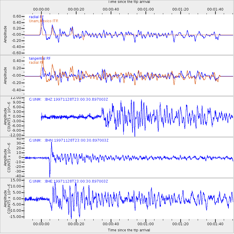
UNM Unam,Mexico - Earthquake Result Viewer
*The percent match for this event was below the threshold and hence no stack was calculated.
| Earthquake location: |
Peru-Bolivia Border Region |
| Earthquake latitude/longitude: |
-13.7/-68.8 |
| Earthquake time(UTC): |
1997/11/28 (332) 22:53:41 GMT |
| Earthquake Depth: |
586 km |
| Earthquake Magnitude: |
6.4 MB, 6.6 UNKNOWN, 6.6 MW |
| Earthquake Catalog/Contributor: |
WHDF/NEIC |
|
| Network: |
G GEOSCOPE |
| Station: |
UNM Unam,Mexico |
| Lat/Lon: |
19.33 N/99.18 W |
| Elevation: |
2280 m |
|
| Distance: |
44.4 deg |
| Az: |
316.982 deg |
| Baz: |
135.409 deg |
| Ray Param: |
$rayparam |
*The percent match for this event was below the threshold and hence was not used in the summary stack. |
|
| Radial Match: |
78.547775 % |
| Radial Bump: |
400 |
| Transverse Match: |
69.100334 % |
| Transverse Bump: |
400 |
| SOD ConfigId: |
4480 |
| Insert Time: |
2010-02-27 00:42:20.065 +0000 |
| GWidth: |
2.5 |
| Max Bumps: |
400 |
| Tol: |
0.001 |
|
Signal To Noise
| Channel | StoN | STA | LTA |
| G:UNM: :BHN:19971128T23:00:30.897003Z | 10.619382 | 7.1393924E-6 | 6.722983E-7 |
| G:UNM: :BHE:19971128T23:00:30.897003Z | 0.8660038 | 7.082489E-7 | 8.178357E-7 |
| G:UNM: :BHZ:19971128T23:00:30.897003Z | 1.5001744 | 9.4684503E-7 | 6.3115664E-7 |
| Arrivals |
| Ps | |
| PpPs | |
| PsPs/PpSs | |


