You are here: Home > Network List > UW - Pacific Northwest Regional Seismic Network Stations List
> Station UMAT Pilot Rock, OR, USA > Earthquake Result Viewer
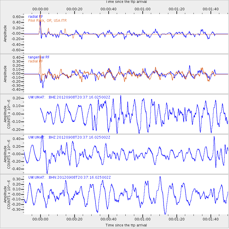
UMAT Pilot Rock, OR, USA - Earthquake Result Viewer
*The percent match for this event was below the threshold and hence no stack was calculated.
| Earthquake location: |
Costa Rica |
| Earthquake latitude/longitude: |
10.1/-85.3 |
| Earthquake time(UTC): |
2012/09/08 (252) 20:29:31 GMT |
| Earthquake Depth: |
35 km |
| Earthquake Magnitude: |
5.7 MB, 5.1 MS, 5.7 MW, 5.7 MW |
| Earthquake Catalog/Contributor: |
WHDF/NEIC |
|
| Network: |
UW Pacific Northwest Regional Seismic Network |
| Station: |
UMAT Pilot Rock, OR, USA |
| Lat/Lon: |
45.29 N/118.96 W |
| Elevation: |
1318 m |
|
| Distance: |
45.4 deg |
| Az: |
326.702 deg |
| Baz: |
130.015 deg |
| Ray Param: |
$rayparam |
*The percent match for this event was below the threshold and hence was not used in the summary stack. |
|
| Radial Match: |
67.439255 % |
| Radial Bump: |
400 |
| Transverse Match: |
65.68296 % |
| Transverse Bump: |
400 |
| SOD ConfigId: |
476835 |
| Insert Time: |
2013-02-22 17:36:02.490 +0000 |
| GWidth: |
2.5 |
| Max Bumps: |
400 |
| Tol: |
0.001 |
|
Signal To Noise
| Channel | StoN | STA | LTA |
| UW:UMAT: :BHZ:20120908T20:37:16.025002Z | 2.5119042 | 2.9116978E-7 | 1.1591596E-7 |
| UW:UMAT: :BHN:20120908T20:37:16.025002Z | 1.3924215 | 1.4312123E-7 | 1.02785854E-7 |
| UW:UMAT: :BHE:20120908T20:37:16.025002Z | 1.7622167 | 1.2874375E-7 | 7.305784E-8 |
| Arrivals |
| Ps | |
| PpPs | |
| PsPs/PpSs | |


