You are here: Home > Network List > IM - International Miscellaneous Stations Stations List
> Station IL31 ILAR Array, Eilson, AK, USA > Earthquake Result Viewer
IL31 ILAR Array, Eilson, AK, USA - Earthquake Result Viewer
| Earthquake location: |
Kuril Islands |
| Earthquake latitude/longitude: |
49.2/155.8 |
| Earthquake time(UTC): |
2012/09/09 (253) 05:39:37 GMT |
| Earthquake Depth: |
31 km |
| Earthquake Magnitude: |
5.5 MB, 5.5 MS, 5.9 MW, 6.0 MW |
| Earthquake Catalog/Contributor: |
WHDF/NEIC |
|
| Network: |
IM International Miscellaneous Stations |
| Station: |
IL31 ILAR Array, Eilson, AK, USA |
| Lat/Lon: |
64.77 N/146.89 W |
| Elevation: |
419 m |
|
| Distance: |
33.5 deg |
| Az: |
40.843 deg |
| Baz: |
270.458 deg |
| Ray Param: |
0.07813309 |
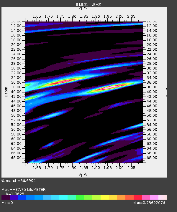
| Estimated Moho Depth: |
37.75 km |
| Estimated Crust Vp/Vs: |
1.96 |
| Assumed Crust Vp: |
6.566 km/s |
| Estimated Crust Vs: |
3.346 km/s |
| Estimated Crust Poisson's Ratio: |
0.32 |
|
| Radial Match: |
86.6904 % |
| Radial Bump: |
400 |
| Transverse Match: |
74.83043 % |
| Transverse Bump: |
400 |
| SOD ConfigId: |
476835 |
| Insert Time: |
2013-02-22 17:45:33.559 +0000 |
| GWidth: |
2.5 |
| Max Bumps: |
400 |
| Tol: |
0.001 |
|

Signal To Noise
| Channel | StoN | STA | LTA |
| IM:IL31: :BHZ:20120909T05:45:43.175Z | 2.4349008 | 4.8581565E-8 | 1.9952175E-8 |
| IM:IL31: :BHN:20120909T05:45:43.175Z | 2.364695 | 2.1574794E-8 | 9.123711E-9 |
| IM:IL31: :BHE:20120909T05:45:43.175Z | 2.6785238 | 3.219273E-8 | 1.2018833E-8 |
| Arrivals |
| Ps | 6.0 SECOND |
| PpPs | 16 SECOND |
| PsPs/PpSs | 22 SECOND |


