You are here: Home > Network List > TA - USArray Transportable Network (new EarthScope stations) Stations List
> Station J04D Umpqua National Forest, Toketee, OR, USA > Earthquake Result Viewer
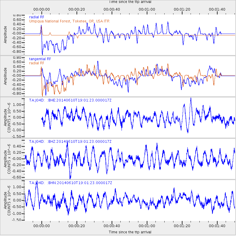
J04D Umpqua National Forest, Toketee, OR, USA - Earthquake Result Viewer
*The percent match for this event was below the threshold and hence no stack was calculated.
| Earthquake location: |
Solomon Islands |
| Earthquake latitude/longitude: |
-6.8/154.6 |
| Earthquake time(UTC): |
2014/06/10 (161) 18:48:59 GMT |
| Earthquake Depth: |
39 km |
| Earthquake Magnitude: |
5.2 MW |
| Earthquake Catalog/Contributor: |
ISC/ISC |
|
| Network: |
TA USArray Transportable Network (new EarthScope stations) |
| Station: |
J04D Umpqua National Forest, Toketee, OR, USA |
| Lat/Lon: |
43.24 N/122.11 W |
| Elevation: |
1948 m |
|
| Distance: |
89.8 deg |
| Az: |
46.535 deg |
| Baz: |
260.489 deg |
| Ray Param: |
$rayparam |
*The percent match for this event was below the threshold and hence was not used in the summary stack. |
|
| Radial Match: |
50.47664 % |
| Radial Bump: |
400 |
| Transverse Match: |
55.50511 % |
| Transverse Bump: |
400 |
| SOD ConfigId: |
3390531 |
| Insert Time: |
2019-04-12 05:58:46.763 +0000 |
| GWidth: |
2.5 |
| Max Bumps: |
400 |
| Tol: |
0.001 |
|
Signal To Noise
| Channel | StoN | STA | LTA |
| TA:J04D: :BHZ:20140610T19:01:23.000017Z | 1.0174904 | 1.7070775E-7 | 1.6777332E-7 |
| TA:J04D: :BHN:20140610T19:01:23.000017Z | 0.62214226 | 2.1562371E-7 | 3.4658265E-7 |
| TA:J04D: :BHE:20140610T19:01:23.000017Z | 1.487758 | 5.647642E-7 | 3.7960757E-7 |
| Arrivals |
| Ps | |
| PpPs | |
| PsPs/PpSs | |


