You are here: Home > Network List > TA - USArray Transportable Network (new EarthScope stations) Stations List
> Station O38A Galt, MO, USA > Earthquake Result Viewer
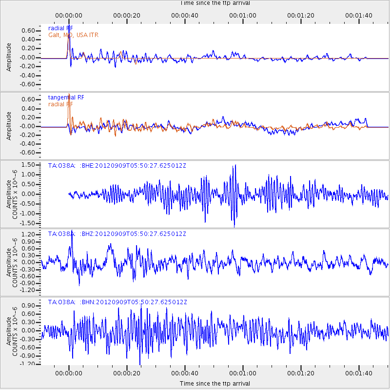
O38A Galt, MO, USA - Earthquake Result Viewer
*The percent match for this event was below the threshold and hence no stack was calculated.
| Earthquake location: |
Kuril Islands |
| Earthquake latitude/longitude: |
49.2/155.8 |
| Earthquake time(UTC): |
2012/09/09 (253) 05:39:37 GMT |
| Earthquake Depth: |
31 km |
| Earthquake Magnitude: |
5.5 MB, 5.5 MS, 5.9 MW, 6.0 MW |
| Earthquake Catalog/Contributor: |
WHDF/NEIC |
|
| Network: |
TA USArray Transportable Network (new EarthScope stations) |
| Station: |
O38A Galt, MO, USA |
| Lat/Lon: |
40.12 N/93.47 W |
| Elevation: |
266 m |
|
| Distance: |
72.1 deg |
| Az: |
48.87 deg |
| Baz: |
319.932 deg |
| Ray Param: |
$rayparam |
*The percent match for this event was below the threshold and hence was not used in the summary stack. |
|
| Radial Match: |
71.61981 % |
| Radial Bump: |
400 |
| Transverse Match: |
53.343624 % |
| Transverse Bump: |
400 |
| SOD ConfigId: |
476835 |
| Insert Time: |
2013-02-22 17:56:56.829 +0000 |
| GWidth: |
2.5 |
| Max Bumps: |
400 |
| Tol: |
0.001 |
|
Signal To Noise
| Channel | StoN | STA | LTA |
| TA:O38A: :BHZ:20120909T05:50:27.625012Z | 3.8140125 | 4.9477444E-7 | 1.2972544E-7 |
| TA:O38A: :BHN:20120909T05:50:27.625012Z | 2.2757006 | 3.5652462E-7 | 1.5666586E-7 |
| TA:O38A: :BHE:20120909T05:50:27.625012Z | 2.4120238 | 4.3045188E-7 | 1.7846088E-7 |
| Arrivals |
| Ps | |
| PpPs | |
| PsPs/PpSs | |


