You are here: Home > Network List > TA - USArray Transportable Network (new EarthScope stations) Stations List
> Station Q43A New Douglas, IL, USA > Earthquake Result Viewer
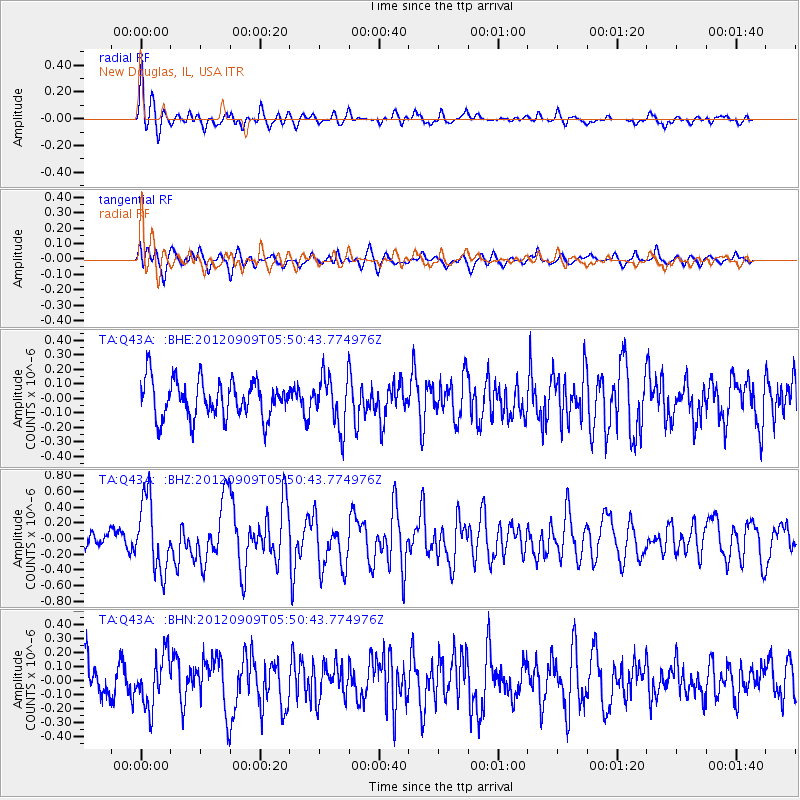
Q43A New Douglas, IL, USA - Earthquake Result Viewer
*The percent match for this event was below the threshold and hence no stack was calculated.
| Earthquake location: |
Kuril Islands |
| Earthquake latitude/longitude: |
49.2/155.8 |
| Earthquake time(UTC): |
2012/09/09 (253) 05:39:37 GMT |
| Earthquake Depth: |
31 km |
| Earthquake Magnitude: |
5.5 MB, 5.5 MS, 5.9 MW, 6.0 MW |
| Earthquake Catalog/Contributor: |
WHDF/NEIC |
|
| Network: |
TA USArray Transportable Network (new EarthScope stations) |
| Station: |
Q43A New Douglas, IL, USA |
| Lat/Lon: |
38.94 N/89.70 W |
| Elevation: |
202 m |
|
| Distance: |
74.9 deg |
| Az: |
47.283 deg |
| Baz: |
321.875 deg |
| Ray Param: |
$rayparam |
*The percent match for this event was below the threshold and hence was not used in the summary stack. |
|
| Radial Match: |
70.21868 % |
| Radial Bump: |
400 |
| Transverse Match: |
52.35743 % |
| Transverse Bump: |
400 |
| SOD ConfigId: |
476835 |
| Insert Time: |
2013-02-22 18:04:21.430 +0000 |
| GWidth: |
2.5 |
| Max Bumps: |
400 |
| Tol: |
0.001 |
|
Signal To Noise
| Channel | StoN | STA | LTA |
| TA:Q43A: :BHZ:20120909T05:50:43.774976Z | 2.8552804 | 4.5630767E-7 | 1.5981186E-7 |
| TA:Q43A: :BHN:20120909T05:50:43.774976Z | 1.5228279 | 1.8377895E-7 | 1.2068269E-7 |
| TA:Q43A: :BHE:20120909T05:50:43.774976Z | 1.3723867 | 1.7738869E-7 | 1.2925561E-7 |
| Arrivals |
| Ps | |
| PpPs | |
| PsPs/PpSs | |


