You are here: Home > Network List > TA - USArray Transportable Network (new EarthScope stations) Stations List
> Station M39A Webster, IA, USA > Earthquake Result Viewer
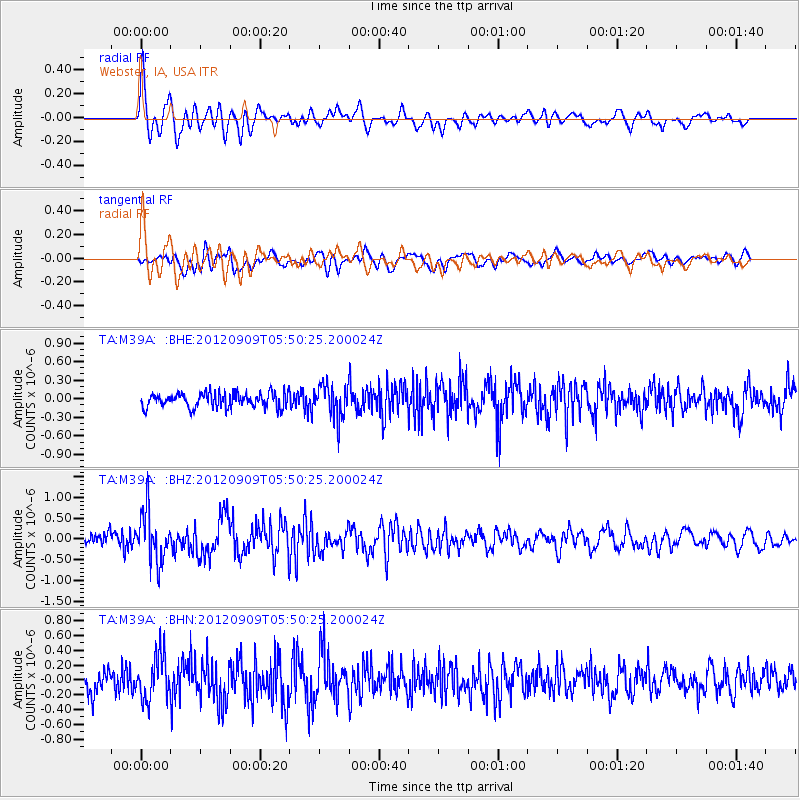
M39A Webster, IA, USA - Earthquake Result Viewer
*The percent match for this event was below the threshold and hence no stack was calculated.
| Earthquake location: |
Kuril Islands |
| Earthquake latitude/longitude: |
49.2/155.8 |
| Earthquake time(UTC): |
2012/09/09 (253) 05:39:37 GMT |
| Earthquake Depth: |
31 km |
| Earthquake Magnitude: |
5.5 MB, 5.5 MS, 5.9 MW, 6.0 MW |
| Earthquake Catalog/Contributor: |
WHDF/NEIC |
|
| Network: |
TA USArray Transportable Network (new EarthScope stations) |
| Station: |
M39A Webster, IA, USA |
| Lat/Lon: |
41.48 N/92.17 W |
| Elevation: |
264 m |
|
| Distance: |
71.7 deg |
| Az: |
47.158 deg |
| Baz: |
320.248 deg |
| Ray Param: |
$rayparam |
*The percent match for this event was below the threshold and hence was not used in the summary stack. |
|
| Radial Match: |
75.719505 % |
| Radial Bump: |
400 |
| Transverse Match: |
62.444237 % |
| Transverse Bump: |
400 |
| SOD ConfigId: |
476835 |
| Insert Time: |
2013-02-22 18:05:21.280 +0000 |
| GWidth: |
2.5 |
| Max Bumps: |
400 |
| Tol: |
0.001 |
|
Signal To Noise
| Channel | StoN | STA | LTA |
| TA:M39A: :BHZ:20120909T05:50:25.200024Z | 4.0067472 | 6.0952607E-7 | 1.5212491E-7 |
| TA:M39A: :BHN:20120909T05:50:25.200024Z | 2.3603888 | 2.987426E-7 | 1.26565E-7 |
| TA:M39A: :BHE:20120909T05:50:25.200024Z | 2.2414863 | 2.6077248E-7 | 1.16339095E-7 |
| Arrivals |
| Ps | |
| PpPs | |
| PsPs/PpSs | |


