You are here: Home > Network List > TA - USArray Transportable Network (new EarthScope stations) Stations List
> Station V43A Jonesboro, AR, USA > Earthquake Result Viewer
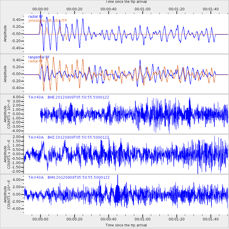
V43A Jonesboro, AR, USA - Earthquake Result Viewer
*The percent match for this event was below the threshold and hence no stack was calculated.
| Earthquake location: |
Kuril Islands |
| Earthquake latitude/longitude: |
49.2/155.8 |
| Earthquake time(UTC): |
2012/09/09 (253) 05:39:37 GMT |
| Earthquake Depth: |
31 km |
| Earthquake Magnitude: |
5.5 MB, 5.5 MS, 5.9 MW, 6.0 MW |
| Earthquake Catalog/Contributor: |
WHDF/NEIC |
|
| Network: |
TA USArray Transportable Network (new EarthScope stations) |
| Station: |
V43A Jonesboro, AR, USA |
| Lat/Lon: |
35.79 N/90.54 W |
| Elevation: |
74 m |
|
| Distance: |
77.0 deg |
| Az: |
49.831 deg |
| Baz: |
321.984 deg |
| Ray Param: |
$rayparam |
*The percent match for this event was below the threshold and hence was not used in the summary stack. |
|
| Radial Match: |
69.531075 % |
| Radial Bump: |
400 |
| Transverse Match: |
50.29809 % |
| Transverse Bump: |
400 |
| SOD ConfigId: |
476835 |
| Insert Time: |
2013-02-22 18:06:08.799 +0000 |
| GWidth: |
2.5 |
| Max Bumps: |
400 |
| Tol: |
0.001 |
|
Signal To Noise
| Channel | StoN | STA | LTA |
| TA:V43A: :BHZ:20120909T05:50:55.500012Z | 2.3469033 | 7.776008E-7 | 3.3133057E-7 |
| TA:V43A: :BHN:20120909T05:50:55.500012Z | 0.9791287 | 7.608094E-7 | 7.77027E-7 |
| TA:V43A: :BHE:20120909T05:50:55.500012Z | 0.7334361 | 7.1175145E-7 | 9.704343E-7 |
| Arrivals |
| Ps | |
| PpPs | |
| PsPs/PpSs | |


