You are here: Home > Network List > TA - USArray Transportable Network (new EarthScope stations) Stations List
> Station R41A Rosebud, MO, USA > Earthquake Result Viewer
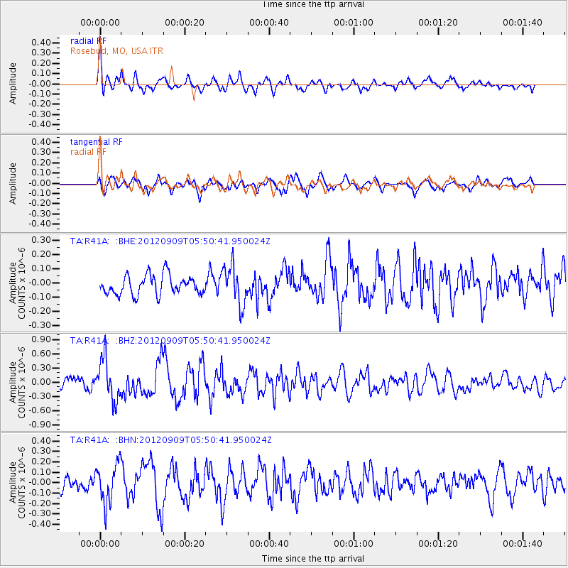
R41A Rosebud, MO, USA - Earthquake Result Viewer
*The percent match for this event was below the threshold and hence no stack was calculated.
| Earthquake location: |
Kuril Islands |
| Earthquake latitude/longitude: |
49.2/155.8 |
| Earthquake time(UTC): |
2012/09/09 (253) 05:39:37 GMT |
| Earthquake Depth: |
31 km |
| Earthquake Magnitude: |
5.5 MB, 5.5 MS, 5.9 MW, 6.0 MW |
| Earthquake Catalog/Contributor: |
WHDF/NEIC |
|
| Network: |
TA USArray Transportable Network (new EarthScope stations) |
| Station: |
R41A Rosebud, MO, USA |
| Lat/Lon: |
38.30 N/91.38 W |
| Elevation: |
257 m |
|
| Distance: |
74.6 deg |
| Az: |
48.765 deg |
| Baz: |
321.22 deg |
| Ray Param: |
$rayparam |
*The percent match for this event was below the threshold and hence was not used in the summary stack. |
|
| Radial Match: |
65.52344 % |
| Radial Bump: |
400 |
| Transverse Match: |
63.77541 % |
| Transverse Bump: |
400 |
| SOD ConfigId: |
476835 |
| Insert Time: |
2013-02-22 18:06:33.448 +0000 |
| GWidth: |
2.5 |
| Max Bumps: |
400 |
| Tol: |
0.001 |
|
Signal To Noise
| Channel | StoN | STA | LTA |
| TA:R41A: :BHZ:20120909T05:50:41.950024Z | 2.8699675 | 4.428927E-7 | 1.5431978E-7 |
| TA:R41A: :BHN:20120909T05:50:41.950024Z | 2.0063553 | 1.9397268E-7 | 9.667913E-8 |
| TA:R41A: :BHE:20120909T05:50:41.950024Z | 2.0718834 | 1.3924205E-7 | 6.720554E-8 |
| Arrivals |
| Ps | |
| PpPs | |
| PsPs/PpSs | |


