You are here: Home > Network List > G - GEOSCOPE Stations List
> Station WUS Wushi, Xinjiang Uygur, China > Earthquake Result Viewer
WUS Wushi, Xinjiang Uygur, China - Earthquake Result Viewer
| Earthquake location: |
Taiwan Region |
| Earthquake latitude/longitude: |
24.0/122.7 |
| Earthquake time(UTC): |
2001/12/18 (352) 04:02:58 GMT |
| Earthquake Depth: |
14 km |
| Earthquake Magnitude: |
6.3 MB, 7.3 MS, 6.9 MW, 6.8 MW |
| Earthquake Catalog/Contributor: |
WHDF/NEIC |
|
| Network: |
G GEOSCOPE |
| Station: |
WUS Wushi, Xinjiang Uygur, China |
| Lat/Lon: |
41.20 N/79.22 E |
| Elevation: |
1457 m |
|
| Distance: |
40.0 deg |
| Az: |
306.135 deg |
| Baz: |
101.719 deg |
| Ray Param: |
0.07461314 |
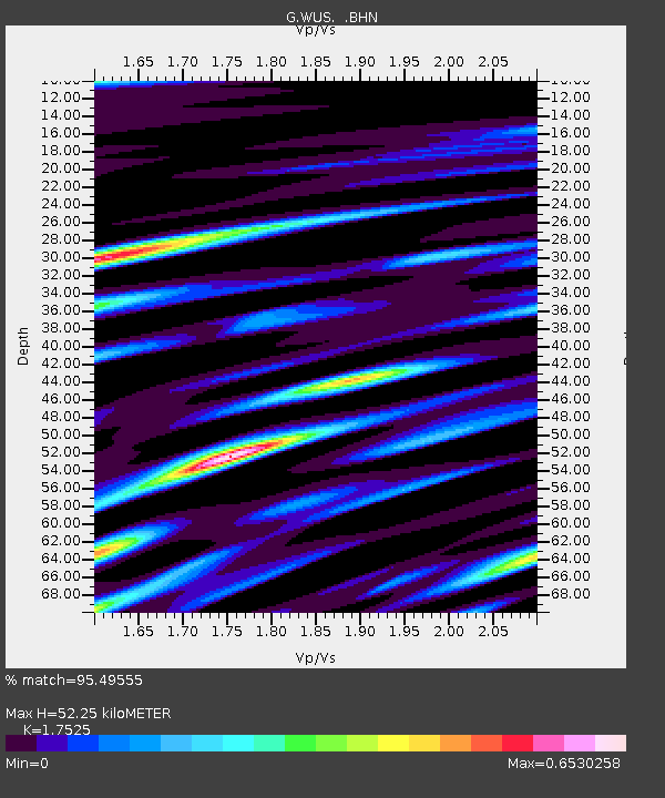
| Estimated Moho Depth: |
52.25 km |
| Estimated Crust Vp/Vs: |
1.75 |
| Assumed Crust Vp: |
6.353 km/s |
| Estimated Crust Vs: |
3.625 km/s |
| Estimated Crust Poisson's Ratio: |
0.26 |
|
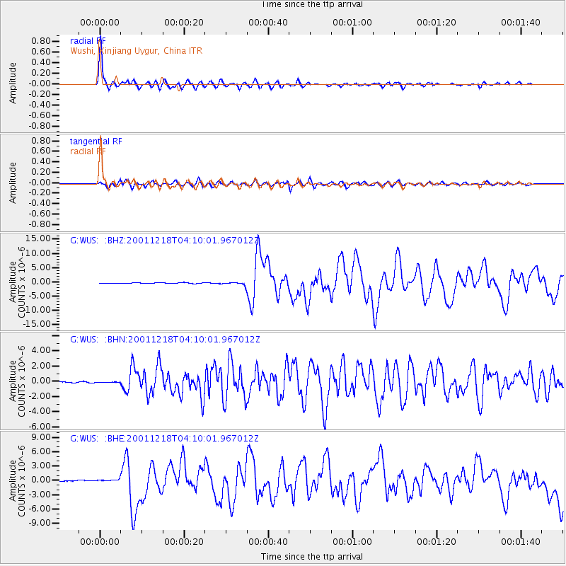
| Radial Match: |
95.49555 % |
| Radial Bump: |
400 |
| Transverse Match: |
86.662224 % |
| Transverse Bump: |
400 |
| SOD ConfigId: |
20082 |
| Insert Time: |
2010-02-27 00:43:10.781 +0000 |
| GWidth: |
2.5 |
| Max Bumps: |
400 |
| Tol: |
0.001 |
|
Signal To Noise
| Channel | StoN | STA | LTA |
| G:WUS: :BHN:20011218T04:10:01.967012Z | 0.8284847 | 4.0880234E-8 | 4.934338E-8 |
| G:WUS: :BHE:20011218T04:10:01.967012Z | 1.8254734 | 1.9048967E-7 | 1.0435083E-7 |
| G:WUS: :BHZ:20011218T04:10:01.967012Z | 3.8866093 | 5.365016E-7 | 1.3803847E-7 |
| Arrivals |
| Ps | 6.6 SECOND |
| PpPs | 21 SECOND |
| PsPs/PpSs | 28 SECOND |


