You are here: Home > Network List > TA - USArray Transportable Network (new EarthScope stations) Stations List
> Station N46A Monticello, IN, USA > Earthquake Result Viewer
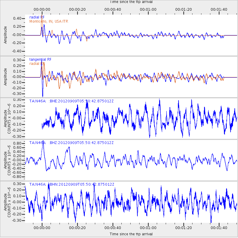
N46A Monticello, IN, USA - Earthquake Result Viewer
*The percent match for this event was below the threshold and hence no stack was calculated.
| Earthquake location: |
Kuril Islands |
| Earthquake latitude/longitude: |
49.2/155.8 |
| Earthquake time(UTC): |
2012/09/09 (253) 05:39:37 GMT |
| Earthquake Depth: |
31 km |
| Earthquake Magnitude: |
5.5 MB, 5.5 MS, 5.9 MW, 6.0 MW |
| Earthquake Catalog/Contributor: |
WHDF/NEIC |
|
| Network: |
TA USArray Transportable Network (new EarthScope stations) |
| Station: |
N46A Monticello, IN, USA |
| Lat/Lon: |
40.89 N/86.74 W |
| Elevation: |
209 m |
|
| Distance: |
74.7 deg |
| Az: |
44.178 deg |
| Baz: |
322.957 deg |
| Ray Param: |
$rayparam |
*The percent match for this event was below the threshold and hence was not used in the summary stack. |
|
| Radial Match: |
68.70135 % |
| Radial Bump: |
400 |
| Transverse Match: |
61.749218 % |
| Transverse Bump: |
400 |
| SOD ConfigId: |
476835 |
| Insert Time: |
2013-02-22 18:11:40.158 +0000 |
| GWidth: |
2.5 |
| Max Bumps: |
400 |
| Tol: |
0.001 |
|
Signal To Noise
| Channel | StoN | STA | LTA |
| TA:N46A: :BHZ:20120909T05:50:42.875012Z | 4.0603156 | 4.4709464E-7 | 1.1011327E-7 |
| TA:N46A: :BHN:20120909T05:50:42.875012Z | 1.454203 | 1.4493541E-7 | 9.966656E-8 |
| TA:N46A: :BHE:20120909T05:50:42.875012Z | 1.1563238 | 1.1243412E-7 | 9.723412E-8 |
| Arrivals |
| Ps | |
| PpPs | |
| PsPs/PpSs | |


