You are here: Home > Network List > TA - USArray Transportable Network (new EarthScope stations) Stations List
> Station O45A Potomac, IL, USA > Earthquake Result Viewer
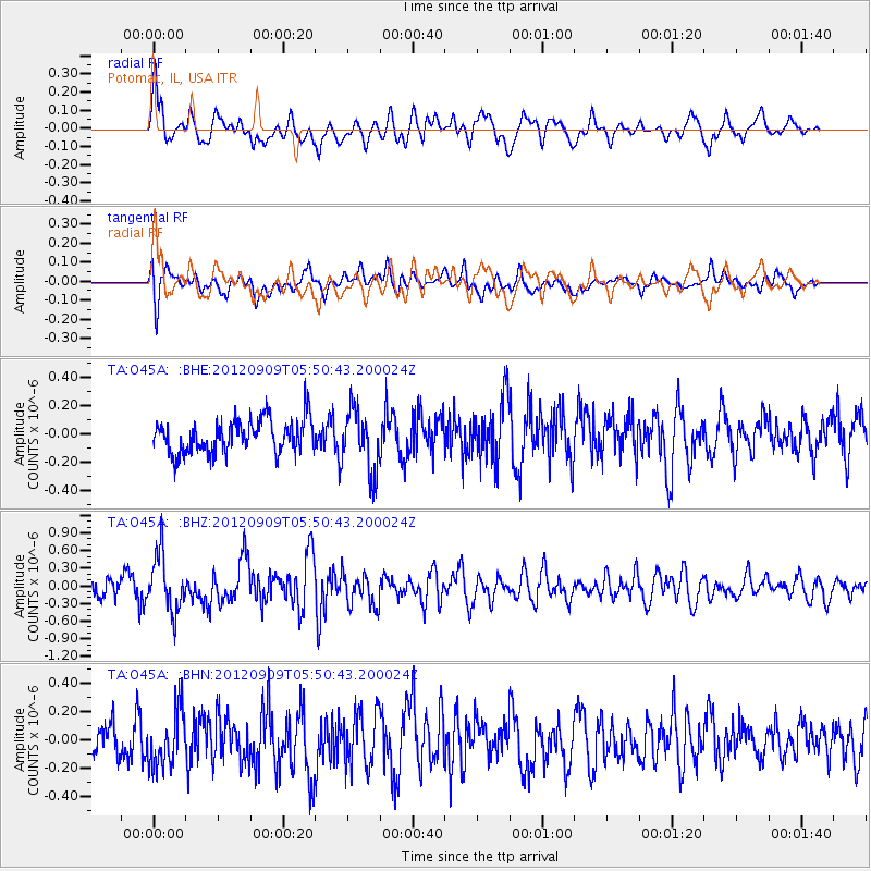
O45A Potomac, IL, USA - Earthquake Result Viewer
*The percent match for this event was below the threshold and hence no stack was calculated.
| Earthquake location: |
Kuril Islands |
| Earthquake latitude/longitude: |
49.2/155.8 |
| Earthquake time(UTC): |
2012/09/09 (253) 05:39:37 GMT |
| Earthquake Depth: |
31 km |
| Earthquake Magnitude: |
5.5 MB, 5.5 MS, 5.9 MW, 6.0 MW |
| Earthquake Catalog/Contributor: |
WHDF/NEIC |
|
| Network: |
TA USArray Transportable Network (new EarthScope stations) |
| Station: |
O45A Potomac, IL, USA |
| Lat/Lon: |
40.25 N/87.72 W |
| Elevation: |
208 m |
|
| Distance: |
74.8 deg |
| Az: |
45.205 deg |
| Baz: |
322.585 deg |
| Ray Param: |
$rayparam |
*The percent match for this event was below the threshold and hence was not used in the summary stack. |
|
| Radial Match: |
68.66172 % |
| Radial Bump: |
400 |
| Transverse Match: |
57.68039 % |
| Transverse Bump: |
400 |
| SOD ConfigId: |
476835 |
| Insert Time: |
2013-02-22 18:12:06.224 +0000 |
| GWidth: |
2.5 |
| Max Bumps: |
400 |
| Tol: |
0.001 |
|
Signal To Noise
| Channel | StoN | STA | LTA |
| TA:O45A: :BHZ:20120909T05:50:43.200024Z | 2.957349 | 4.805751E-7 | 1.62502E-7 |
| TA:O45A: :BHN:20120909T05:50:43.200024Z | 1.8055615 | 1.976419E-7 | 1.09462846E-7 |
| TA:O45A: :BHE:20120909T05:50:43.200024Z | 1.8434615 | 2.1706063E-7 | 1.1774622E-7 |
| Arrivals |
| Ps | |
| PpPs | |
| PsPs/PpSs | |


