You are here: Home > Network List > G - GEOSCOPE Stations List
> Station WUS Wushi, Xinjiang Uygur, China > Earthquake Result Viewer
WUS Wushi, Xinjiang Uygur, China - Earthquake Result Viewer
| Earthquake location: |
Eastern Honshu, Japan |
| Earthquake latitude/longitude: |
39.4/141.1 |
| Earthquake time(UTC): |
2001/12/02 (336) 13:01:53 GMT |
| Earthquake Depth: |
124 km |
| Earthquake Magnitude: |
6.1 MB, 6.5 MW, 6.5 MW |
| Earthquake Catalog/Contributor: |
WHDF/NEIC |
|
| Network: |
G GEOSCOPE |
| Station: |
WUS Wushi, Xinjiang Uygur, China |
| Lat/Lon: |
41.20 N/79.22 E |
| Elevation: |
1457 m |
|
| Distance: |
46.3 deg |
| Az: |
293.073 deg |
| Baz: |
70.842 deg |
| Ray Param: |
0.07027724 |
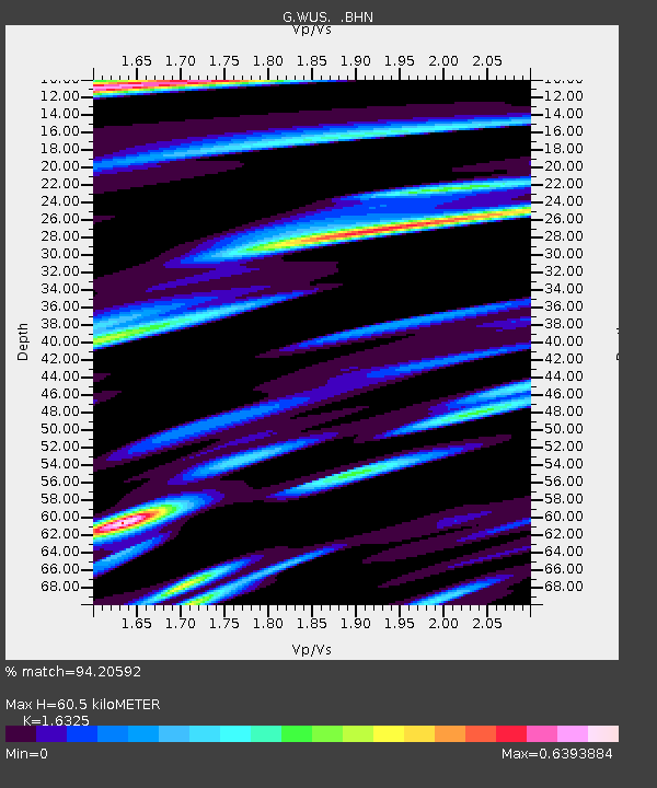
| Estimated Moho Depth: |
60.5 km |
| Estimated Crust Vp/Vs: |
1.63 |
| Assumed Crust Vp: |
6.353 km/s |
| Estimated Crust Vs: |
3.892 km/s |
| Estimated Crust Poisson's Ratio: |
0.20 |
|
| Radial Match: |
94.20592 % |
| Radial Bump: |
400 |
| Transverse Match: |
84.20986 % |
| Transverse Bump: |
400 |
| SOD ConfigId: |
20082 |
| Insert Time: |
2010-02-27 00:43:16.904 +0000 |
| GWidth: |
2.5 |
| Max Bumps: |
400 |
| Tol: |
0.001 |
|
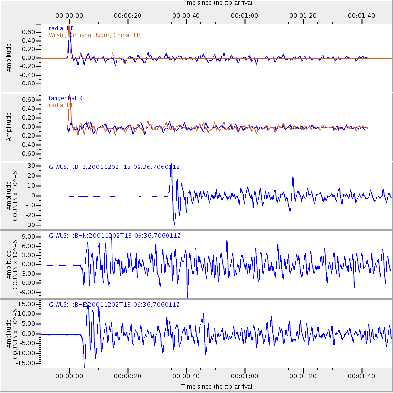
Signal To Noise
| Channel | StoN | STA | LTA |
| G:WUS: :BHN:20011202T13:09:36.706011Z | 19.54428 | 1.3283928E-6 | 6.796838E-8 |
| G:WUS: :BHE:20011202T13:09:36.706011Z | 38.315475 | 2.0409582E-6 | 5.32672E-8 |
| G:WUS: :BHZ:20011202T13:09:36.706011Z | 120.85188 | 6.786482E-6 | 5.615537E-8 |
| Arrivals |
| Ps | 6.4 SECOND |
| PpPs | 23 SECOND |
| PsPs/PpSs | 30 SECOND |


