You are here: Home > Network List > TA - USArray Transportable Network (new EarthScope stations) Stations List
> Station Z50A Ashland, AL, USA > Earthquake Result Viewer
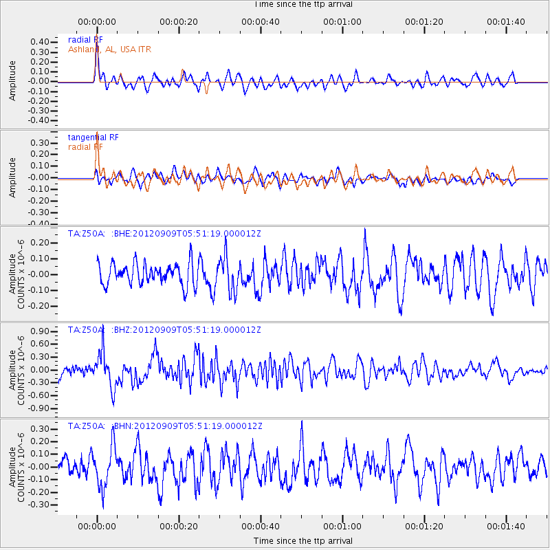
Z50A Ashland, AL, USA - Earthquake Result Viewer
*The percent match for this event was below the threshold and hence no stack was calculated.
| Earthquake location: |
Kuril Islands |
| Earthquake latitude/longitude: |
49.2/155.8 |
| Earthquake time(UTC): |
2012/09/09 (253) 05:39:37 GMT |
| Earthquake Depth: |
31 km |
| Earthquake Magnitude: |
5.5 MB, 5.5 MS, 5.9 MW, 6.0 MW |
| Earthquake Catalog/Contributor: |
WHDF/NEIC |
|
| Network: |
TA USArray Transportable Network (new EarthScope stations) |
| Station: |
Z50A Ashland, AL, USA |
| Lat/Lon: |
33.25 N/85.92 W |
| Elevation: |
370 m |
|
| Distance: |
81.3 deg |
| Az: |
48.264 deg |
| Baz: |
324.296 deg |
| Ray Param: |
$rayparam |
*The percent match for this event was below the threshold and hence was not used in the summary stack. |
|
| Radial Match: |
71.24058 % |
| Radial Bump: |
400 |
| Transverse Match: |
55.92532 % |
| Transverse Bump: |
400 |
| SOD ConfigId: |
476835 |
| Insert Time: |
2013-02-22 18:15:25.998 +0000 |
| GWidth: |
2.5 |
| Max Bumps: |
400 |
| Tol: |
0.001 |
|
Signal To Noise
| Channel | StoN | STA | LTA |
| TA:Z50A: :BHZ:20120909T05:51:19.000012Z | 3.5084593 | 4.2554726E-7 | 1.2129178E-7 |
| TA:Z50A: :BHN:20120909T05:51:19.000012Z | 2.3235056 | 1.6311222E-7 | 7.020091E-8 |
| TA:Z50A: :BHE:20120909T05:51:19.000012Z | 1.6156472 | 1.0888468E-7 | 6.739385E-8 |
| Arrivals |
| Ps | |
| PpPs | |
| PsPs/PpSs | |


