You are here: Home > Network List > G - GEOSCOPE Stations List
> Station WUS Wushi, Xinjiang Uygur, China > Earthquake Result Viewer
WUS Wushi, Xinjiang Uygur, China - Earthquake Result Viewer
| Earthquake location: |
Banda Sea |
| Earthquake latitude/longitude: |
-4.1/123.9 |
| Earthquake time(UTC): |
2001/10/19 (292) 03:28:44 GMT |
| Earthquake Depth: |
33 km |
| Earthquake Magnitude: |
6.3 MB, 7.3 MS, 7.5 MW, 7.4 MW |
| Earthquake Catalog/Contributor: |
WHDF/NEIC |
|
| Network: |
G GEOSCOPE |
| Station: |
WUS Wushi, Xinjiang Uygur, China |
| Lat/Lon: |
41.20 N/79.22 E |
| Elevation: |
1457 m |
|
| Distance: |
60.8 deg |
| Az: |
322.541 deg |
| Baz: |
126.493 deg |
| Ray Param: |
0.061264325 |
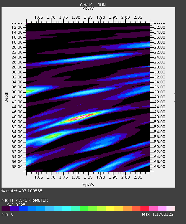
| Estimated Moho Depth: |
47.75 km |
| Estimated Crust Vp/Vs: |
1.82 |
| Assumed Crust Vp: |
6.353 km/s |
| Estimated Crust Vs: |
3.486 km/s |
| Estimated Crust Poisson's Ratio: |
0.28 |
|
| Radial Match: |
97.100555 % |
| Radial Bump: |
388 |
| Transverse Match: |
87.201385 % |
| Transverse Bump: |
400 |
| SOD ConfigId: |
20082 |
| Insert Time: |
2010-02-27 00:43:29.563 +0000 |
| GWidth: |
2.5 |
| Max Bumps: |
400 |
| Tol: |
0.001 |
|
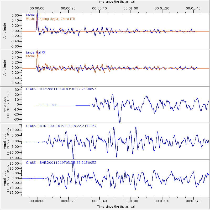
Signal To Noise
| Channel | StoN | STA | LTA |
| G:WUS: :BHN:20011019T03:38:22.215005Z | 3.3976157 | 2.722671E-7 | 8.0134754E-8 |
| G:WUS: :BHE:20011019T03:38:22.215005Z | 4.8884706 | 3.282549E-7 | 6.71488E-8 |
| G:WUS: :BHZ:20011019T03:38:22.215005Z | 4.209017 | 6.586798E-7 | 1.5649255E-7 |
| Arrivals |
| Ps | 6.5 SECOND |
| PpPs | 20 SECOND |
| PsPs/PpSs | 27 SECOND |


