You are here: Home > Network List > TA - USArray Transportable Network (new EarthScope stations) Stations List
> Station Q50A Georgetown, OH, USA > Earthquake Result Viewer
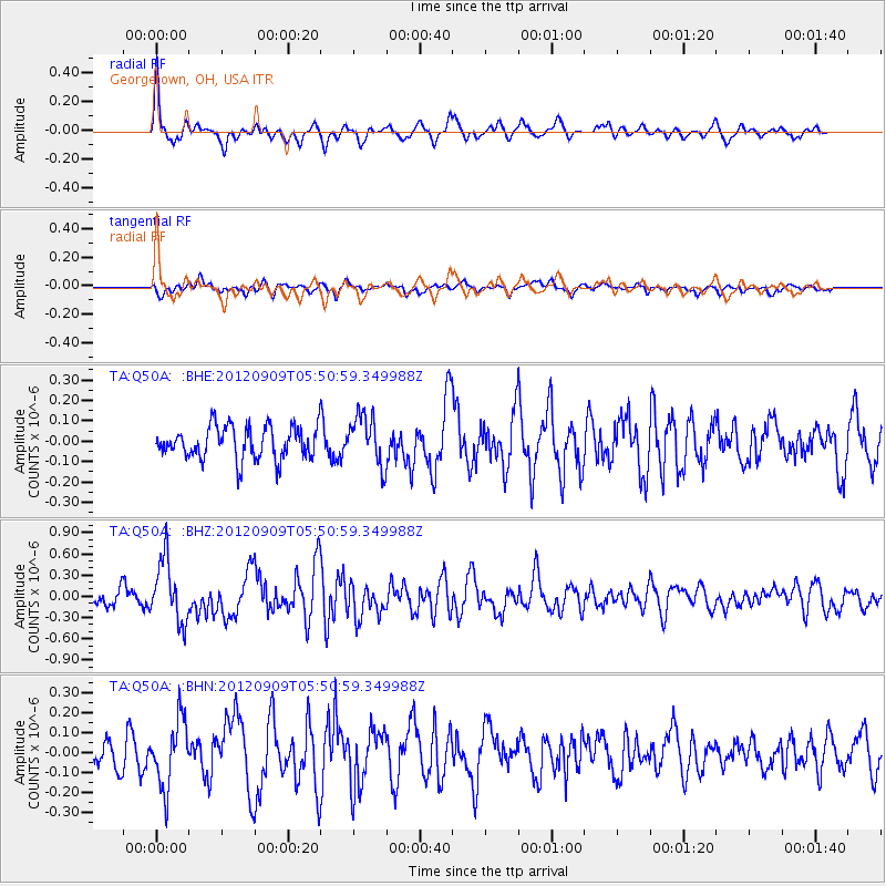
Q50A Georgetown, OH, USA - Earthquake Result Viewer
*The percent match for this event was below the threshold and hence no stack was calculated.
| Earthquake location: |
Kuril Islands |
| Earthquake latitude/longitude: |
49.2/155.8 |
| Earthquake time(UTC): |
2012/09/09 (253) 05:39:37 GMT |
| Earthquake Depth: |
31 km |
| Earthquake Magnitude: |
5.5 MB, 5.5 MS, 5.9 MW, 6.0 MW |
| Earthquake Catalog/Contributor: |
WHDF/NEIC |
|
| Network: |
TA USArray Transportable Network (new EarthScope stations) |
| Station: |
Q50A Georgetown, OH, USA |
| Lat/Lon: |
38.84 N/83.98 W |
| Elevation: |
262 m |
|
| Distance: |
77.7 deg |
| Az: |
43.663 deg |
| Baz: |
324.594 deg |
| Ray Param: |
$rayparam |
*The percent match for this event was below the threshold and hence was not used in the summary stack. |
|
| Radial Match: |
67.6952 % |
| Radial Bump: |
366 |
| Transverse Match: |
48.032764 % |
| Transverse Bump: |
394 |
| SOD ConfigId: |
476835 |
| Insert Time: |
2013-02-22 18:22:47.877 +0000 |
| GWidth: |
2.5 |
| Max Bumps: |
400 |
| Tol: |
0.001 |
|
Signal To Noise
| Channel | StoN | STA | LTA |
| TA:Q50A: :BHZ:20120909T05:50:59.349988Z | 4.3309884 | 4.417216E-7 | 1.0199094E-7 |
| TA:Q50A: :BHN:20120909T05:50:59.349988Z | 2.232039 | 1.7014997E-7 | 7.6230734E-8 |
| TA:Q50A: :BHE:20120909T05:50:59.349988Z | 1.5369834 | 1.2243517E-7 | 7.9659394E-8 |
| Arrivals |
| Ps | |
| PpPs | |
| PsPs/PpSs | |


