You are here: Home > Network List > TA - USArray Transportable Network (new EarthScope stations) Stations List
> Station M49A Liberty Center, OH, USA > Earthquake Result Viewer
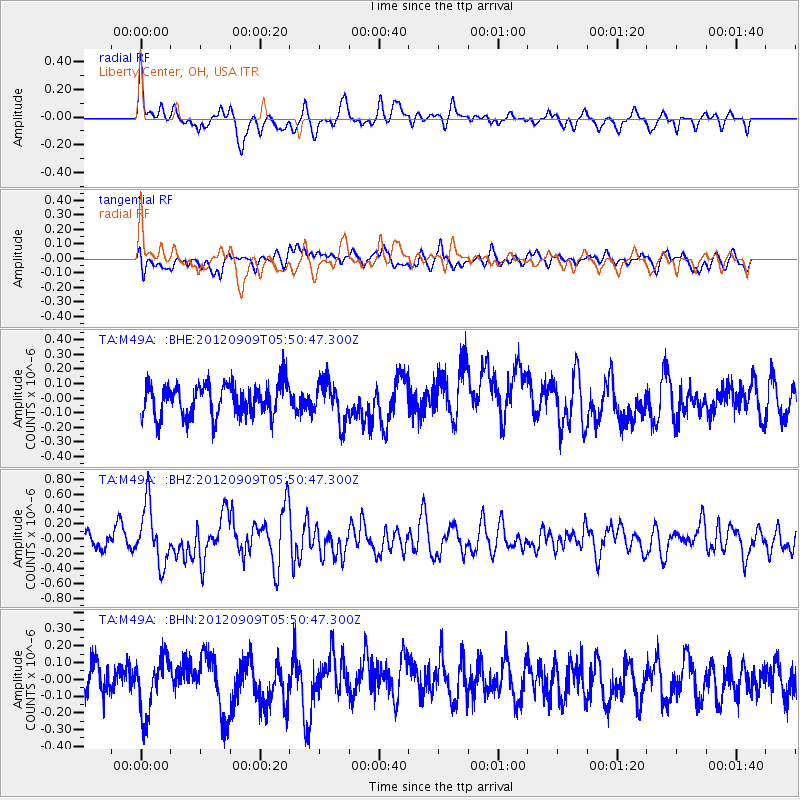
M49A Liberty Center, OH, USA - Earthquake Result Viewer
*The percent match for this event was below the threshold and hence no stack was calculated.
| Earthquake location: |
Kuril Islands |
| Earthquake latitude/longitude: |
49.2/155.8 |
| Earthquake time(UTC): |
2012/09/09 (253) 05:39:37 GMT |
| Earthquake Depth: |
31 km |
| Earthquake Magnitude: |
5.5 MB, 5.5 MS, 5.9 MW, 6.0 MW |
| Earthquake Catalog/Contributor: |
WHDF/NEIC |
|
| Network: |
TA USArray Transportable Network (new EarthScope stations) |
| Station: |
M49A Liberty Center, OH, USA |
| Lat/Lon: |
41.47 N/83.98 W |
| Elevation: |
203 m |
|
| Distance: |
75.5 deg |
| Az: |
42.088 deg |
| Baz: |
324.231 deg |
| Ray Param: |
$rayparam |
*The percent match for this event was below the threshold and hence was not used in the summary stack. |
|
| Radial Match: |
63.38564 % |
| Radial Bump: |
400 |
| Transverse Match: |
50.51454 % |
| Transverse Bump: |
400 |
| SOD ConfigId: |
476835 |
| Insert Time: |
2013-02-22 18:23:30.612 +0000 |
| GWidth: |
2.5 |
| Max Bumps: |
400 |
| Tol: |
0.001 |
|
Signal To Noise
| Channel | StoN | STA | LTA |
| TA:M49A: :BHZ:20120909T05:50:47.300Z | 3.1925273 | 3.8781693E-7 | 1.2147646E-7 |
| TA:M49A: :BHN:20120909T05:50:47.300Z | 1.1667495 | 1.6474583E-7 | 1.4120069E-7 |
| TA:M49A: :BHE:20120909T05:50:47.300Z | 1.2503915 | 1.3794818E-7 | 1.1032399E-7 |
| Arrivals |
| Ps | |
| PpPs | |
| PsPs/PpSs | |


