You are here: Home > Network List > TA - USArray Transportable Network (new EarthScope stations) Stations List
> Station N49A Columbus Grove, OH, USA > Earthquake Result Viewer
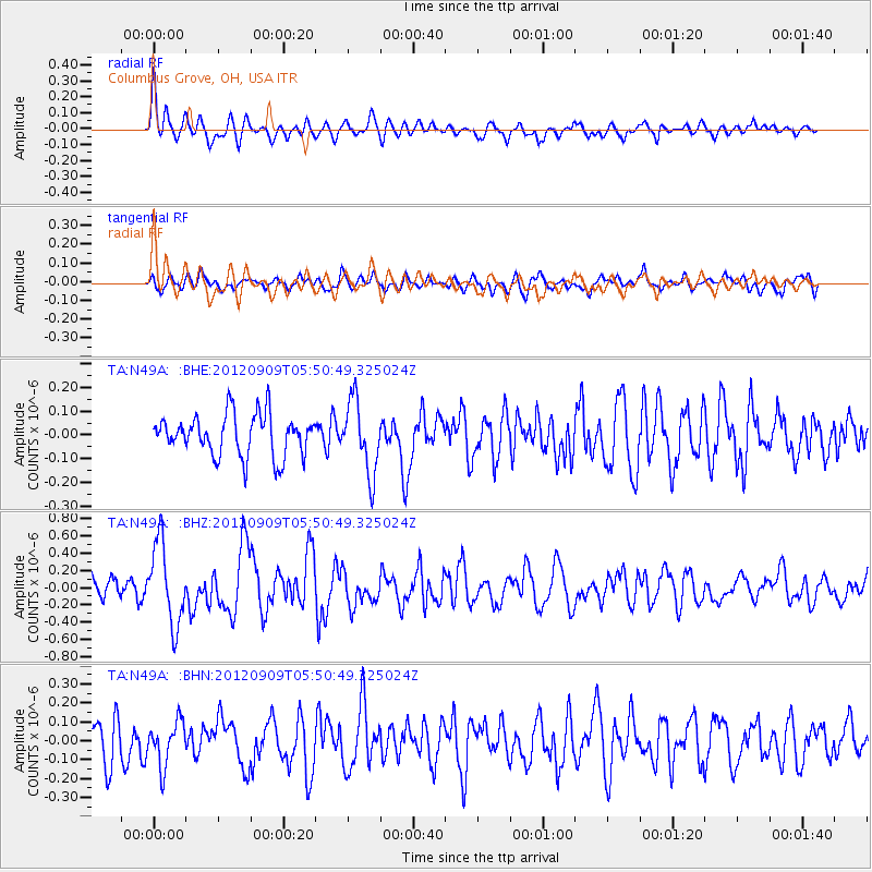
N49A Columbus Grove, OH, USA - Earthquake Result Viewer
*The percent match for this event was below the threshold and hence no stack was calculated.
| Earthquake location: |
Kuril Islands |
| Earthquake latitude/longitude: |
49.2/155.8 |
| Earthquake time(UTC): |
2012/09/09 (253) 05:39:37 GMT |
| Earthquake Depth: |
31 km |
| Earthquake Magnitude: |
5.5 MB, 5.5 MS, 5.9 MW, 6.0 MW |
| Earthquake Catalog/Contributor: |
WHDF/NEIC |
|
| Network: |
TA USArray Transportable Network (new EarthScope stations) |
| Station: |
N49A Columbus Grove, OH, USA |
| Lat/Lon: |
40.92 N/84.18 W |
| Elevation: |
225 m |
|
| Distance: |
75.9 deg |
| Az: |
42.552 deg |
| Baz: |
324.21 deg |
| Ray Param: |
$rayparam |
*The percent match for this event was below the threshold and hence was not used in the summary stack. |
|
| Radial Match: |
71.95982 % |
| Radial Bump: |
400 |
| Transverse Match: |
52.074333 % |
| Transverse Bump: |
400 |
| SOD ConfigId: |
476835 |
| Insert Time: |
2013-02-22 18:25:12.470 +0000 |
| GWidth: |
2.5 |
| Max Bumps: |
400 |
| Tol: |
0.001 |
|
Signal To Noise
| Channel | StoN | STA | LTA |
| TA:N49A: :BHZ:20120909T05:50:49.325024Z | 2.6874254 | 4.6989803E-7 | 1.7485063E-7 |
| TA:N49A: :BHN:20120909T05:50:49.325024Z | 1.1261804 | 1.16868335E-7 | 1.0377408E-7 |
| TA:N49A: :BHE:20120909T05:50:49.325024Z | 1.7475487 | 1.52224E-7 | 8.710716E-8 |
| Arrivals |
| Ps | |
| PpPs | |
| PsPs/PpSs | |


