You are here: Home > Network List > UW - Pacific Northwest Regional Seismic Network Stations List
> Station MRBL Marblemount, WA, USA > Earthquake Result Viewer
MRBL Marblemount, WA, USA - Earthquake Result Viewer
*The percent match for this event was below the threshold and hence no stack was calculated.
| Earthquake location: |
Kuril Islands |
| Earthquake latitude/longitude: |
49.2/155.8 |
| Earthquake time(UTC): |
2012/09/09 (253) 05:39:37 GMT |
| Earthquake Depth: |
31 km |
| Earthquake Magnitude: |
5.5 MB, 5.5 MS, 5.9 MW, 6.0 MW |
| Earthquake Catalog/Contributor: |
WHDF/NEIC |
|
| Network: |
UW Pacific Northwest Regional Seismic Network |
| Station: |
MRBL Marblemount, WA, USA |
| Lat/Lon: |
48.52 N/121.48 W |
| Elevation: |
75 m |
|
| Distance: |
51.8 deg |
| Az: |
57.128 deg |
| Baz: |
304.126 deg |
| Ray Param: |
$rayparam |
*The percent match for this event was below the threshold and hence was not used in the summary stack. |
|
| Radial Match: |
69.18581 % |
| Radial Bump: |
400 |
| Transverse Match: |
52.307846 % |
| Transverse Bump: |
400 |
| SOD ConfigId: |
476835 |
| Insert Time: |
2013-02-22 18:26:31.909 +0000 |
| GWidth: |
2.5 |
| Max Bumps: |
400 |
| Tol: |
0.001 |
|
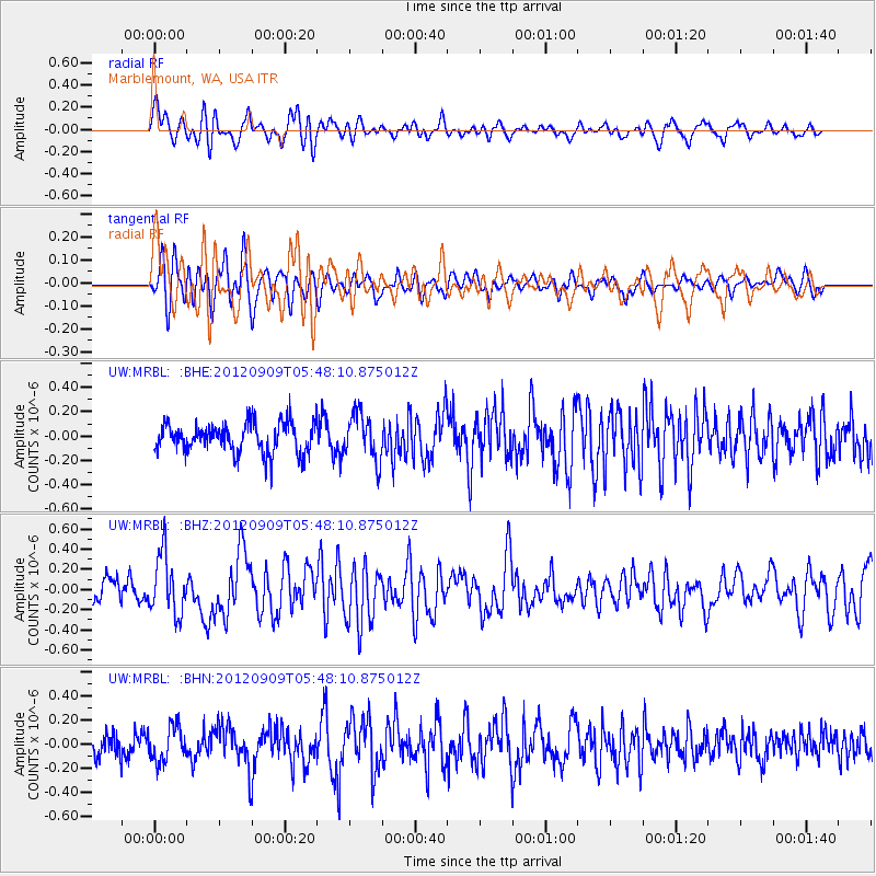
Signal To Noise
| Channel | StoN | STA | LTA |
| UW:MRBL: :BHZ:20120909T05:48:10.875012Z | 3.234014 | 2.9726849E-7 | 9.1919354E-8 |
| UW:MRBL: :BHN:20120909T05:48:10.875012Z | 1.2427092 | 1.430421E-7 | 1.1510505E-7 |
| UW:MRBL: :BHE:20120909T05:48:10.875012Z | 1.5247302 | 1.8954056E-7 | 1.2431087E-7 |
| Arrivals |
| Ps | |
| PpPs | |
| PsPs/PpSs | |


