You are here: Home > Network List > CI - Caltech Regional Seismic Network Stations List
> Station SWS Sam W. Stewart, Westmorland, CA, USA > Earthquake Result Viewer
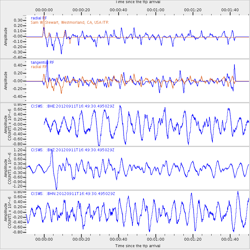
SWS Sam W. Stewart, Westmorland, CA, USA - Earthquake Result Viewer
*The percent match for this event was below the threshold and hence no stack was calculated.
| Earthquake location: |
South Of Mariana Islands |
| Earthquake latitude/longitude: |
11.8/143.2 |
| Earthquake time(UTC): |
2012/09/11 (255) 16:36:49 GMT |
| Earthquake Depth: |
8.0 km |
| Earthquake Magnitude: |
5.8 MB, 5.7 MS, 5.9 MW, 5.8 MW |
| Earthquake Catalog/Contributor: |
WHDF/NEIC |
|
| Network: |
CI Caltech Regional Seismic Network |
| Station: |
SWS Sam W. Stewart, Westmorland, CA, USA |
| Lat/Lon: |
32.94 N/115.80 W |
| Elevation: |
140 m |
|
| Distance: |
92.7 deg |
| Az: |
55.729 deg |
| Baz: |
285.823 deg |
| Ray Param: |
$rayparam |
*The percent match for this event was below the threshold and hence was not used in the summary stack. |
|
| Radial Match: |
43.23381 % |
| Radial Bump: |
329 |
| Transverse Match: |
58.032047 % |
| Transverse Bump: |
400 |
| SOD ConfigId: |
476835 |
| Insert Time: |
2013-02-22 18:39:07.521 +0000 |
| GWidth: |
2.5 |
| Max Bumps: |
400 |
| Tol: |
0.001 |
|
Signal To Noise
| Channel | StoN | STA | LTA |
| CI:SWS: :BHZ:20120911T16:49:30.495029Z | 4.6518307 | 4.812179E-7 | 1.03447E-7 |
| CI:SWS: :BHN:20120911T16:49:30.495029Z | 0.9390522 | 2.560748E-7 | 2.7269493E-7 |
| CI:SWS: :BHE:20120911T16:49:30.495029Z | 2.1599677 | 5.116121E-7 | 2.36861E-7 |
| Arrivals |
| Ps | |
| PpPs | |
| PsPs/PpSs | |


