You are here: Home > Network List > CI - Caltech Regional Seismic Network Stations List
> Station MPM Manuel Prospect Mine, California, USA > Earthquake Result Viewer
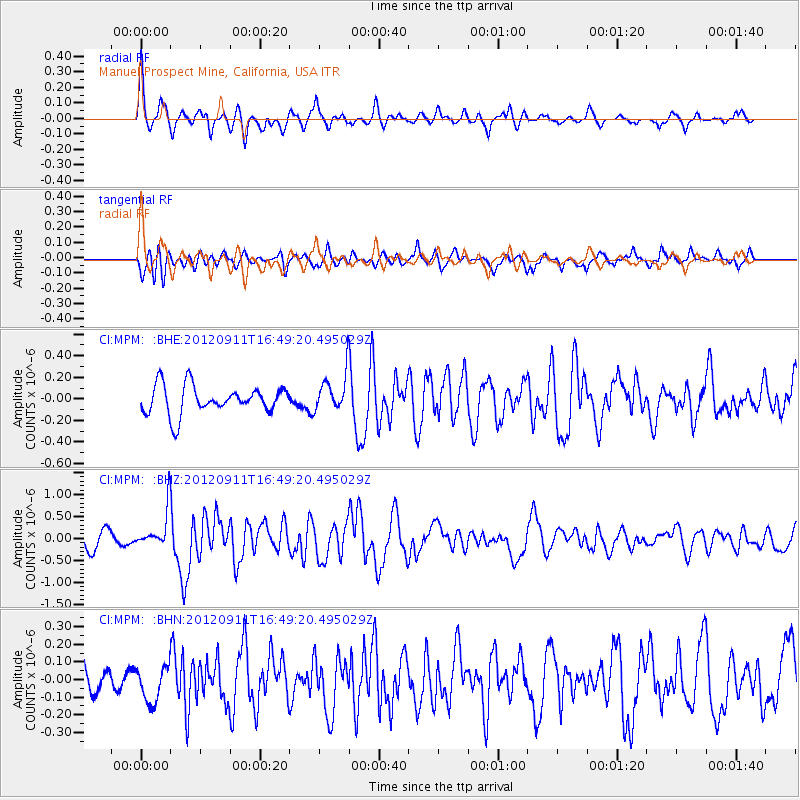
MPM Manuel Prospect Mine, California, USA - Earthquake Result Viewer
*The percent match for this event was below the threshold and hence no stack was calculated.
| Earthquake location: |
South Of Mariana Islands |
| Earthquake latitude/longitude: |
11.8/143.2 |
| Earthquake time(UTC): |
2012/09/11 (255) 16:36:49 GMT |
| Earthquake Depth: |
8.0 km |
| Earthquake Magnitude: |
5.8 MB, 5.7 MS, 5.9 MW, 5.8 MW |
| Earthquake Catalog/Contributor: |
WHDF/NEIC |
|
| Network: |
CI Caltech Regional Seismic Network |
| Station: |
MPM Manuel Prospect Mine, California, USA |
| Lat/Lon: |
36.06 N/117.49 W |
| Elevation: |
185 m |
|
| Distance: |
90.5 deg |
| Az: |
53.101 deg |
| Baz: |
284.941 deg |
| Ray Param: |
$rayparam |
*The percent match for this event was below the threshold and hence was not used in the summary stack. |
|
| Radial Match: |
72.93515 % |
| Radial Bump: |
400 |
| Transverse Match: |
61.599903 % |
| Transverse Bump: |
400 |
| SOD ConfigId: |
476835 |
| Insert Time: |
2013-02-22 18:39:09.849 +0000 |
| GWidth: |
2.5 |
| Max Bumps: |
400 |
| Tol: |
0.001 |
|
Signal To Noise
| Channel | StoN | STA | LTA |
| CI:MPM: :BHZ:20120911T16:49:20.495029Z | 2.4754198 | 4.2539577E-7 | 1.7184793E-7 |
| CI:MPM: :BHN:20120911T16:49:20.495029Z | 0.71208805 | 1.03025506E-7 | 1.4468085E-7 |
| CI:MPM: :BHE:20120911T16:49:20.495029Z | 1.3344755 | 1.7471496E-7 | 1.3092406E-7 |
| Arrivals |
| Ps | |
| PpPs | |
| PsPs/PpSs | |


