You are here: Home > Network List > UW - Pacific Northwest Regional Seismic Network Stations List
> Station UMAT Pilot Rock, OR, USA > Earthquake Result Viewer
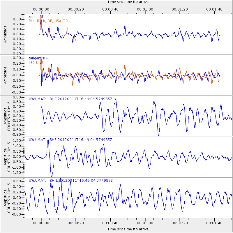
UMAT Pilot Rock, OR, USA - Earthquake Result Viewer
*The percent match for this event was below the threshold and hence no stack was calculated.
| Earthquake location: |
South Of Mariana Islands |
| Earthquake latitude/longitude: |
11.8/143.2 |
| Earthquake time(UTC): |
2012/09/11 (255) 16:36:49 GMT |
| Earthquake Depth: |
8.0 km |
| Earthquake Magnitude: |
5.8 MB, 5.7 MS, 5.9 MW, 5.8 MW |
| Earthquake Catalog/Contributor: |
WHDF/NEIC |
|
| Network: |
UW Pacific Northwest Regional Seismic Network |
| Station: |
UMAT Pilot Rock, OR, USA |
| Lat/Lon: |
45.29 N/118.96 W |
| Elevation: |
1318 m |
|
| Distance: |
87.1 deg |
| Az: |
44.444 deg |
| Baz: |
283.802 deg |
| Ray Param: |
$rayparam |
*The percent match for this event was below the threshold and hence was not used in the summary stack. |
|
| Radial Match: |
68.582436 % |
| Radial Bump: |
338 |
| Transverse Match: |
55.43407 % |
| Transverse Bump: |
400 |
| SOD ConfigId: |
476835 |
| Insert Time: |
2013-02-22 18:47:52.067 +0000 |
| GWidth: |
2.5 |
| Max Bumps: |
400 |
| Tol: |
0.001 |
|
Signal To Noise
| Channel | StoN | STA | LTA |
| UW:UMAT: :BHZ:20120911T16:49:04.574985Z | 3.106521 | 6.226249E-7 | 2.0042515E-7 |
| UW:UMAT: :BHN:20120911T16:49:04.574985Z | 1.6581353 | 3.1119723E-7 | 1.8767903E-7 |
| UW:UMAT: :BHE:20120911T16:49:04.574985Z | 1.6898606 | 2.448678E-7 | 1.4490413E-7 |
| Arrivals |
| Ps | |
| PpPs | |
| PsPs/PpSs | |


