You are here: Home > Network List > G - GEOSCOPE Stations List
> Station WUS Wushi, Xinjiang Uygur, China > Earthquake Result Viewer
WUS Wushi, Xinjiang Uygur, China - Earthquake Result Viewer
| Earthquake location: |
Solomon Islands |
| Earthquake latitude/longitude: |
-7.0/155.0 |
| Earthquake time(UTC): |
2001/05/29 (149) 23:37:19 GMT |
| Earthquake Depth: |
14 km |
| Earthquake Magnitude: |
5.7 MB, 6.4 MS, 6.4 MW, 5.7 ME |
| Earthquake Catalog/Contributor: |
WHDF/NEIC |
|
| Network: |
G GEOSCOPE |
| Station: |
WUS Wushi, Xinjiang Uygur, China |
| Lat/Lon: |
41.20 N/79.22 E |
| Elevation: |
1457 m |
|
| Distance: |
84.0 deg |
| Az: |
312.643 deg |
| Baz: |
104.63 deg |
| Ray Param: |
0.04575271 |
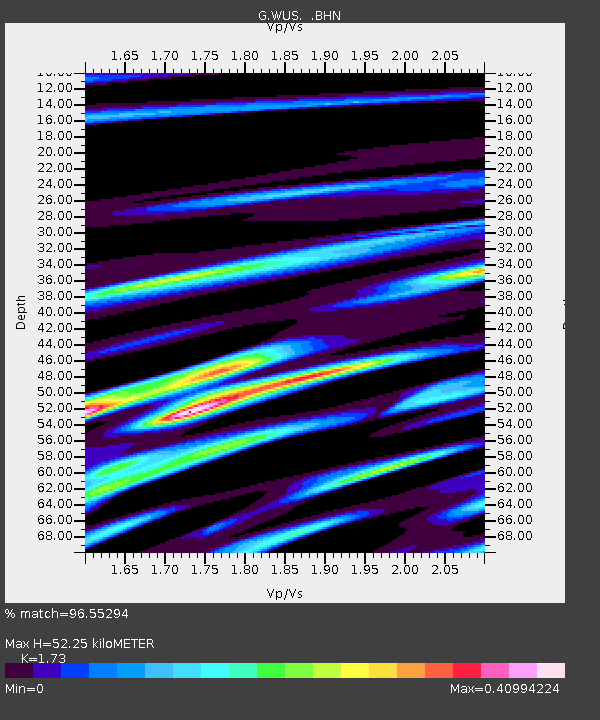
| Estimated Moho Depth: |
52.25 km |
| Estimated Crust Vp/Vs: |
1.73 |
| Assumed Crust Vp: |
6.353 km/s |
| Estimated Crust Vs: |
3.672 km/s |
| Estimated Crust Poisson's Ratio: |
0.25 |
|
| Radial Match: |
96.55294 % |
| Radial Bump: |
400 |
| Transverse Match: |
80.59508 % |
| Transverse Bump: |
400 |
| SOD ConfigId: |
4714 |
| Insert Time: |
2010-02-27 00:44:26.430 +0000 |
| GWidth: |
2.5 |
| Max Bumps: |
400 |
| Tol: |
0.001 |
|
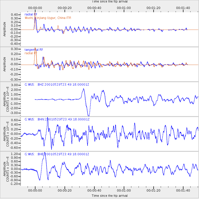
Signal To Noise
| Channel | StoN | STA | LTA |
| G:WUS: :BHN:20010529T23:49:18.00001Z | 2.2142222 | 1.1310722E-7 | 5.1082143E-8 |
| G:WUS: :BHE:20010529T23:49:18.00001Z | 13.571451 | 4.584543E-7 | 3.378079E-8 |
| G:WUS: :BHZ:20010529T23:49:18.00001Z | 21.471128 | 1.2096947E-6 | 5.634053E-8 |
| Arrivals |
| Ps | 6.2 SECOND |
| PpPs | 22 SECOND |
| PsPs/PpSs | 28 SECOND |


