You are here: Home > Network List > TA - USArray Transportable Network (new EarthScope stations) Stations List
> Station X46A Booneville, MS, USA > Earthquake Result Viewer
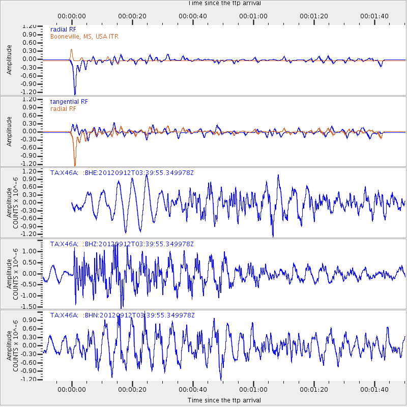
X46A Booneville, MS, USA - Earthquake Result Viewer
*The percent match for this event was below the threshold and hence no stack was calculated.
| Earthquake location: |
Crete, Greece |
| Earthquake latitude/longitude: |
34.8/24.1 |
| Earthquake time(UTC): |
2012/09/12 (256) 03:27:46 GMT |
| Earthquake Depth: |
32 km |
| Earthquake Magnitude: |
5.7 MB, 5.0 MS, 5.5 MW, 5.3 MW |
| Earthquake Catalog/Contributor: |
WHDF/NEIC |
|
| Network: |
TA USArray Transportable Network (new EarthScope stations) |
| Station: |
X46A Booneville, MS, USA |
| Lat/Lon: |
34.56 N/88.58 W |
| Elevation: |
150 m |
|
| Distance: |
86.6 deg |
| Az: |
310.293 deg |
| Baz: |
49.525 deg |
| Ray Param: |
$rayparam |
*The percent match for this event was below the threshold and hence was not used in the summary stack. |
|
| Radial Match: |
81.02812 % |
| Radial Bump: |
400 |
| Transverse Match: |
40.014324 % |
| Transverse Bump: |
400 |
| SOD ConfigId: |
476835 |
| Insert Time: |
2013-02-22 18:59:32.481 +0000 |
| GWidth: |
2.5 |
| Max Bumps: |
400 |
| Tol: |
0.001 |
|
Signal To Noise
| Channel | StoN | STA | LTA |
| TA:X46A: :BHZ:20120912T03:39:55.349978Z | 3.2882352 | 5.13784E-7 | 1.5624916E-7 |
| TA:X46A: :BHN:20120912T03:39:55.349978Z | 0.8880291 | 2.3787764E-7 | 2.6787146E-7 |
| TA:X46A: :BHE:20120912T03:39:55.349978Z | 0.55020446 | 2.712276E-7 | 4.9295784E-7 |
| Arrivals |
| Ps | |
| PpPs | |
| PsPs/PpSs | |


