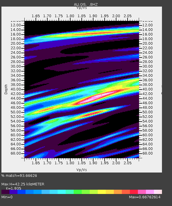
QIS Mount Isa, Queensland - Earthquake Result Viewer

Earthquake location: Southern Sumatra, Indonesia
Earthquake latitude/longitude: -3.3/100.6
Earthquake time(UTC): 2012/09/14 (258) 04:51:47 GMT
Earthquake Depth: 19 km
Earthquake Magnitude: 6.1 MB, 6.3 MS, 6.2 MW, 6.2 MW
Earthquake Catalog/Contributor: WHDF/NEIC
Network: AU Australian Seismological Centre
Station: QIS Mount Isa, Queensland
Lat/Lon: 20.56 S/139.61 E
Elevation: 450 m
Distance: 41.7 deg
Az: 117.467 deg
Baz: 289.043 deg
Ray Param: 0.07362262
Estimated Moho Depth: 42.25 km
Estimated Crust Vp/Vs: 1.93
Assumed Crust Vp: 6.577 km/s
Estimated Crust Vs: 3.399 km/s
Estimated Crust Poisson's Ratio: 0.32
Radial Match: 93.66626 %
Radial Bump: 235
Transverse Match: 84.863045 %
Transverse Bump: 348
SOD ConfigId: 476835
Insert Time: 2013-02-22 19:06:15.271 +0000
GWidth: 2.5
Max Bumps: 400
Tol: 0.001

Signal To Noise

ChannelStoNSTALTA
AU:QIS: :BHZ:20120914T04:59:03.469994Z7.78953551.2117163E-61.5555693E-7
AU:QIS: :BHN:20120914T04:59:03.469994Z1.0171891.292351E-71.2705122E-7
AU:QIS: :BHE:20120914T04:59:03.469994Z5.5809437.269511E-71.3025596E-7
Arrivals
Ps6.4 SECOND
PpPs18 SECOND
PsPs/PpSs24 SECOND