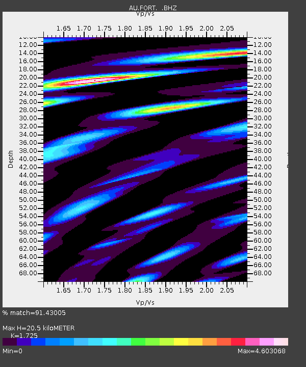
FORT Forrest, WA - Earthquake Result Viewer

Earthquake location: Southern Sumatra, Indonesia
Earthquake latitude/longitude: -3.3/100.6
Earthquake time(UTC): 2012/09/14 (258) 04:51:47 GMT
Earthquake Depth: 19 km
Earthquake Magnitude: 6.1 MB, 6.3 MS, 6.2 MW, 6.2 MW
Earthquake Catalog/Contributor: WHDF/NEIC
Network: AU Australian Seismological Centre
Station: FORT Forrest, WA
Lat/Lon: 30.78 S/128.06 E
Elevation: 165 m
Distance: 37.7 deg
Az: 139.48 deg
Baz: 311.092 deg
Ray Param: 0.075990535
Estimated Moho Depth: 20.5 km
Estimated Crust Vp/Vs: 1.73
Assumed Crust Vp: 6.479 km/s
Estimated Crust Vs: 3.756 km/s
Estimated Crust Poisson's Ratio: 0.25
Radial Match: 91.43005 %
Radial Bump: 400
Transverse Match: 85.91558 %
Transverse Bump: 400
SOD ConfigId: 476835
Insert Time: 2013-02-22 19:06:18.022 +0000
GWidth: 2.5
Max Bumps: 400
Tol: 0.001

Signal To Noise

ChannelStoNSTALTA
AU:FORT: :BHZ:20120914T04:58:30.145012Z3.62858418.656275E-72.3855793E-7
AU:FORT: :BHN:20120914T04:58:30.145012Z1.91355786.146705E-73.2121866E-7
AU:FORT: :BHE:20120914T04:58:30.145012Z2.13209155.902339E-72.768333E-7
Arrivals
Ps2.5 SECOND
PpPs8.0 SECOND
PsPs/PpSs10 SECOND